18. Mapping the Damon Family's Influence on Westvale
When Calvin Carver Damon bought the mill from James Derby in 1834, also included in the purchase was the Bellows Factory Lot and fifteen acres of land in south Acton. From Damon’s original acquisition came over time a succession of land purchases and home building that expanded the Damon family’s presence in Westvale section of Concord, and in doing so, created a neighborhood.
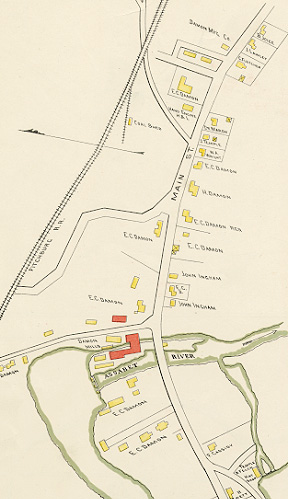
The 1852 Walling map of Concord shows C.C. Damon’s cotton and woolen mill standing out among the other mills and manufactories along the banks of the Assabet River. Two decades later the Beers Atlas devoted a detailed section to Westvale (here shown), in which the extent of the Damon family’s real estate holdings is clearly illustrated. By 1875 they owned the mill complex, which included buildings on both sides of the river, additional property beyond the school building, three houselots, including the Grove Lot, and a substantial lot of land on the opposite side of Main Street.
1889 would turn out to be the year the mortgaged mill was finally auctioned by the Middlesex Institution for Savings, ending the Damon family’s reign in Westvale. This section of the Walker map (published in that year) shows, in addition to property still called “Damon Mills,” six house lots, including two that had formerly belonged to the Brown family, residents of West Concord even longer than the Damons.
In addition to the draft manuscript Thoreau survey and to printed maps of Damon property, a sketch or tracing prepared by lawyer Charles Hosmer Walcott to accompany his deed research also survives among Concord Free Public Library holdings.
Support for the Concord Historic Buildings Website was provided in part by contributions to the Bradley P. Dean Memorial Fund.
© 2009 Concord Free Public Library. No part of this site - text or image - may be reproduced in any form without permission from the Concord Free Public Library.
Contact/Feedback: Webmaster Get help viewing and using the site
![]()
 Web design: Tracey Zellmann