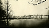
 From Out of the Past—Nashawtuc Hill 1883
Concord Journal, June 30, 1949
The entire Nashawtuc Hill area was part of the old Simon Willard farm owned in 1883 by C. H. Hurd. The town started the construction of the reservoir on the hilltop on May 3rd of that year. It was unusually dry at the time and the rocky hardpan made digging extremely difficult. Mr. Hurd hired the same contractors to build the present causeway bridge (which he presented to the town). From the bridge to the hill was built with the fill, which was removed preparatory to building the reservoir. The following spring, however, was unusually wet and the fill (so hard when dry) soaked up the moisture readily and started to disintegrate. As a result much of the causeway and the abutment at one end of the bridge had to be rebuilt. In rebuilding, the town widened the causeway and, this time, used gravel and sod to prevent future washing away during the spring floods.
The lonely house, which appears in the picture [not identical to the photograph used on this webpage], is the home of William Wheeler. His home was the first building on the hill and it was not until 13 years later that a second house was erected there. Mr. Wheeler laid out roads and planted the trees, which are now growing on the hill. Besides running the farm he devoted much of his time to his profession, civil and consulting engineer. He was the engineer who planned the bridge as well as Concord’s water supply and the reservoir.
William Wheeler was a brother of the late Frank Wheeler of Nine Acre Corner. He was also a brother of the late Harvey Wheeler, founder of the Old Boston Harness Company, and Miss Mary Wheeler, who is still living. All three brothers were very civic minded and served the town well in many important capacities. In his profession as an engineer William Wheeler spent some time in Japan establishing an agricultural college there with a commission from the Japanese government, but most of his life he lived in Concord.
The town water system was first projected in 1873 and then depended on Sandy Pond (Lincoln) as a direct source of supply through gravity flow. In 1883 the town obtained permission from the State to use Nagog Pond as a source of supply and it was at this time that the Nashawtuc reservoir was built, in anticipation, so the town could supply water to the reformatory. The charge for water depended at that time on the number of faucets in each house so that the water department might have a steady income. Our charge for water now is controlled entirely by accurate meter measurement in each home, with much resultant saving to the taxpayers.
The reservoir on Annursnac Hill was built at about the turn of the century. It is from this reservoir (supplied by Nagog) that we now get most of our water but the Nashawtuc reservoir is still used to some extent with part of its supply still coming from Sandy Pond and the balance from Nagog.
Concord’s per capita consumption of water has always been extremely large as compared to other towns in the state.
When your reporter showed the above picture to Mr. John Watson, one of our older town fathers, and asked him if he remembered the hill when it looked like that, he said, “Indeed I do and even before the Wheeler house was built. We kids used to raise h—l up in that area.”
The early history of Nashawtuc Hill farm is very interesting. Written record states that the first WHITE owner of the hill and the woodlands, meadows and arable land attached to it was Major Simon Willard. In fact Concord probably owed more to him than to any other single person. It was he who selected the spot on which the town now stands, and by his influence with the natives promoted its peaceful transition.
The last known Indian owner of Concord (or Musketaquid as the Indians called it) was Squaw Sachem, who inherited the authority of her husband and ruled her tribe with an iron hand. It is presumed that Simon Willard purchased Nashawtuc Hill and its environs from this same Squaw Sachem.
The hill farm was next owned by Dr. Joseph Lee, who lived in Revolutionary times. The farm changed hands down through the early 19th century and the twelfth owner was one Squire Joseph Barrett, according to the records. It is assumed that C. H. Hurd bought the farm from Barrett or his immediate descendants.
Nashawtuc Hill has had many names, the earliest of which was North Hill. Then it became in succession: Lee’s Hill, Barrett’s Hill, Hurd’s Hill and finally reverted back to Nashawtuc Hill, which was its Indian name, meaning simply “between the rivers.” The Indians used to hold tribe meetings at “Egg Rock,” which lies at the junction between the Sudbury and Assabet Rivers and the “Squaw Sachem Trail,” may still be followed from Musterfield Road on the west side of the hill thence around its side and down through the woods to “Egg Rock.” The Simon Willard Farm was actually bounded by the two rivers and extended to an undetermined point just beyond what is now Musketaquid Road.