38. Sanborn Fire Insurance Map, 1909
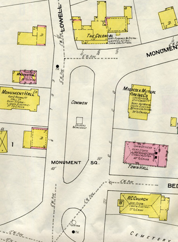
Since the 1860s, the Sanborn Map Company of Pelham, New York has published and updated fire insurance maps of many American cities and towns. The company was established to provide insurance agents with detailed information permitting the assessment of the potential fire hazard of specific properties. Sanborn atlases present a town in multiple sections, which are numbered and identified on an index page. The maps provide valuable research information - building footprints and uses, construction materials and wall thickness, the location of windows and doors, the proximity of water and gas mains and of fire hydrants, the presence of fire suppression systems, and so on. However, they do not always represent all properties within a given town. Often, they include only those likely to be of greatest concern to insurance companies, such as those in the most densely built areas, as is the case with Concord.
This section of Map No. 6 in the 1909 Sanborn atlas of Concord shows the Town House (here identified as "Town Hall"). Color coding indicates that the building is made of brick, the structures on either side of it (insurance company and St. Bernard's Church) of wood.
Support for the Concord Historic Buildings Website was provided in part by contributions to the Bradley P. Dean Memorial Fund.
© 2006 Concord Free Public Library. No part of this site - text or image - may be reproduced in any form without permission from the Concord Free Public Library.
Contact/Feedback: Webmaster Get help viewing and using the site
![]()
 Web design: Tracey Zellmann