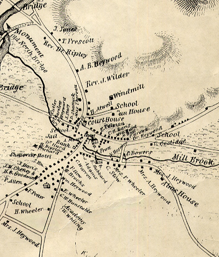
3. Hales Map, 1830
The 1830 map of Concord by John G. Hales was published by Lemuel Shattuck (1793-1859) - Concord's first systematic historian - and included in Shattuck's A History of the Town of Concord; Middlesex County, Massachusetts, from Its Earliest Settlement to 1832; and of the Adjoining Towns, Bedford, Acton, Lincoln, and Carlisle (Boston: Russell, Odiorne and Company; Concord: John Stacy, 1835). Shattuck, brother of Daniel Shattuck (who kept store in part of what is now the Colonial Inn building), lived in Concord from 1823 to 1833. His 1835 history grew out of a series of articles that he wrote for the Yeoman's Gazette. After he left Concord, Shattuck did important work in the areas of social statistics, census, and public health.
The Monument Square section of the Hales map shows the area around the Town House well before Bedford Street was laid out.
Support for the Concord Historic Buildings Website was provided in part by contributions to the Bradley P. Dean Memorial Fund.
© 2006 Concord Free Public Library. No part of this site - text or image - may be reproduced in any form without permission from the Concord Free Public Library.
Contact/Feedback: Webmaster Get help viewing and using the site
![]()
 Web design: Tracey Zellmann