Theodore Lincoln Smith Panoramic Photographs of Concord, Massachusetts (primarily related to the construction of the Route 2 by-pass), 1929, 1931-1937, 1940 and undated
Vault B5, Unit 25
EXTENT: Two containers.
ORGANIZATION: Organized in two series. Series I: Predominantly Concord images, arranged in chronological order, 1929, 1931-1937, 1940 (collection includes a few images of locations in Belmont, Carlisle and Lincoln); Series II: Sudbury and unknown location, undated.
BIOGRAPHY: The collection is made up of photographs, chiefly panoramic, taken by Theodore Lincoln Smith (1877-1949). The son of Henry Francis and Hannah Smith, he was a Spanish-American War veteran, a graduate of M.I.T., and a lifelong Concord resident. He served as town’s Road Commissioner from 1934 until 1943.
HISTORY: The building of Route 2 commenced during the 1910s with the construction of the Mohawk Trail. By 1929, the Taconic Trail, Route 2 west of Williamstown, had been completed. Generally progressing from west to east, 1932 saw the completion of the by-pass at Montague that took the highway through the towns of Erving and Gill. By 1933 preparations—including land-takings—were already in place for the construction of a four lane by-pass that would run along the southern margin of Concord. At the same time, work was underway on the Boston-Cambridge end and when both projects were completed, would extend Route 2 from the Cambridge rotary to the Concord rotary. The approximately 4.5 miles of highway running through Concord began at the Lincoln-Concord town line, continued up the hill near the Walden Pond State Reservation and passed over the Boston & Maine Railroad tracks west of Walden Pond. It then crossed the Sudbury River near the hospital before ending in front of the Reformatory. There it would be joined in time by the “new” Route 2, being built from west to east, which would follow the general course of the Harvard Road, terminating at Westminster, where it would rejoin the “old” Route 2. A significant portion of the construction was done as a W.P.A. project.
SCOPE & CONTENT: The majority of the images in this collection are related to the construction of the Route 2 by-pass in Concord that took place during the 1930s. Shown are locations under construction, as well as those that had yet to be impacted. Most images are of the Concord landscape and include roads and turnpikes, intersections and junctions, town bounds, woodlands, wetlands, farms, fields and bodies of water. Also included are the Minute Man Statue at the North Bridge, railroad tracks, bridges, automobiles, and construction vehicles.
Images taken in March 1936 focus on the effects on Concord of the All-New England Flood, a major weather event that impacted the entire region. Concord experienced record high water levels and extensive flooding.
Most, but not all, of the images are panoramic, measuring 10.5” horizontally x 3.5” vertically. The remainder measure 4” horizontally and 3.5” vertically.
PROCESSED BY: Preliminary processing by Barbara Ewen; additional processing and finding aid by C. Manoli-Skocay, April 2014.
Container lists
Series I: Predominantly Concord images, 1929, 1931-1937, 1940
|
Date |
|
|
|
|
|
|
|
Town bound at Watertown Corner. |
October 12, 1929 |
Yes |
Yes 2 |
|
The Old Town bound at Powder Mill Corner. |
October 12, 1929 |
Yes |
Yes 2 |
|
|
|
|
|
From Belmont Reservoir, No.1. |
1931 |
Yes |
Yes |
|
From Belmont Reservoir, No.2. |
1931 |
Yes |
Yes |
|
Goose Pond. |
April 1931 |
No |
Yes |
|
Alec Higginson Estate and old Baker Farm; Baker’s Bridge. |
April 20, 1931 |
Yes |
Yes |
|
|
|
|
|
Walden Street. |
August 14, 1932 |
Yes |
No |
|
|
|
|
|
Upriver from Railroad Bridge near Wood Street. |
April 19, 1933 |
Yes |
Yes |
|
Wright’s Bridge, Nine Acre Corner. |
April 19, 1933 |
Yes |
Yes |
|
Nine Acre Corner from the Stow Road looking toward Wright’s Bridge. |
April 19, 1933 |
Yes |
Yes |
|
Downriver from Nashawtuc Bridge. |
April 19, 1933 |
Yes, 2 |
Yes |
|
Downriver from Heath’s Bridge. |
April 19, 1933 |
Yes |
Yes |
|
Elm Street Bridge from Main Street. |
April 19, 1933 |
Yes 2 |
Yes 2 |
|
Looking Upriver from Carlisle Bridge |
April 19, 1933 |
Yes |
Yes 2 |
|
Looking West from Ministerial woodlots to intersection of proposed by-pass and Walden Street. |
April 19, 1933 |
Yes |
Yes |
|
Lowell Street Bridge from Nashawtuc Hill. |
April 19, 1933 |
Yes |
No |
|
Looking downriver from Carlisle Bridge. |
April 19, 1933 |
Yes |
Yes 2 |
|
Snellings Crossing below South Lincoln Depot, looking west toward Drumlin Farm. |
April 19, 1933 |
Yes |
Yes |
|
|
|
|
|
Looking toward Reformatory Bridge on Elm Street. |
May 26, 1934 |
Yes |
No |
|
The Park from NW corner of Reformatory Wall. |
May 26, 1934 |
Yes |
No |
|
From Main Street to the old Hosmer Farm, site of West R.R. Bridge. |
June 30, 1934 |
Yes |
Yes 2 |
|
View of Cambridge Turnpike just west of Loring Homestead. |
June 30, 1934 |
Yes |
Yes |
|
Looking west toward the site of easterly by-pass bridge near entrance to the “Cut.” |
June 30, 1934 |
Yes |
Yes |
|
Site of new R.R. bridge in the “Cut.” |
June 30, 1934 |
Yes |
No |
|
Between the new R.R. bridge and Hubbardville. |
June 30, 1934 |
Yes |
No |
|
Road to Thoreau’s Cove where by-pass crosses Walden Road. |
June 30, 1934 |
Yes 2 |
Yes |
|
Cambridge Turnpike looking west toward Old Stone Crusher. |
June 30, 1934 |
Yes |
Yes |
|
Looking west across the Long Swamp to the Cambridge Turnpike. |
June 30, 1934 |
Yes |
No |
|
Cambridge Turnpike. |
June 30, 1934 |
Yes |
No |
|
Where the new road will pass through Hubbardville from Sudbury Road at corner of Potter Street toward Emerson Hospital. |
June 30, 1934 |
|
|
|
View toward Concord from west side of new by-pass bridge over R.R. near entrance to the “Cut.” |
June 30, 1934 |
Yes |
Yes |
|
Allen Farm at junction of by-pass near Elm Street. |
July 4, 1934 |
Yes |
No |
|
Looking toward Allen Farm from Main Street, Sheehan Homestead at Left. |
July 4, 1934 |
Yes |
Yes |
|
Elm Street going toward Reformatory Bridge. |
July 4, 1934 |
Yes |
Yes |
|
Farm hands at work on Allen Farm at junction of by-pass and Elm Street. |
July 7, 1934 |
Yes |
No |
|
Reformatory Bridge (elms and maples along the causeway already down). |
July 22, 1934 |
Yes 2 |
Yes |
|
Looking toward Hubbardville from Clam Shell Bluff. |
July 22, 1934 |
Yes |
Yes |
|
Looking down Sudbury River from Clam Shell Bluff. |
July 22, 1934 |
Yes |
Yes |
|
Looking down Sudbury River toward Fitchburg R.R. Bridge from French’s meadow. |
July 22, 1934 |
Yes |
Yes |
|
Looking up the Sudbury River from Clam Shell Bluff |
July 22, 1934 |
Yes |
Yes |
|
Looking east on the Turnpike from Old Stone Crusher. |
August 5, 1934 |
Yes |
No |
|
Looking east on the turnpike across the Long Swamp. |
August 5, 1934 |
Yes |
No |
|
By-pass crosses R.R. at the “Cut.” |
August 5, 1934 |
Yes |
No |
|
Paine Farm, Lexington Road, looking west toward by-pass corner. |
August 5, 1934 |
Yes |
No |
|
The Old Brooks Farm, Cambridge Turnpike. |
August 5, 1934 |
Yes |
Yes |
|
Lexington Road, where by-pass will turn off to right. |
August 5, 1934 |
Yes |
Yes |
|
Looking east from the Old Stone Crusher. |
August 12, 1934 |
No |
Yes |
|
Charlie Emerson’s house in middle of by-pass right-of-way as it comes up from the bridge near Clam Shell. |
August 12, 1934 |
Yes |
Yes |
|
Concrete mixer partly erected at Intervale Farm. |
August 12, 1934 |
Yes |
No |
|
Where by-pass crosses Intervale Farm, looking east. |
August 12, 1934 |
Yes |
No |
|
Where by-pass crosses Intervale Farm looking west across Sandy Pond Road. |
August 12, 1934 |
Yes |
Yes |
|
Gravestone, Fairhaven Road. |
August 26, 1934 |
Yes |
Yes |
|
Where by-pass crosses Walden Road. |
August 26, 1934 |
Yes |
Yes |
|
Looking towards Reformatory Bridge on Elm Street. |
August 26, 1934 |
Yes |
Yes |
|
Ben Smith’s sand pit in Hubbardville. |
August 26, 1934 |
Yes |
Yes |
|
By-pass east from Sandy Pond Road. |
August 26, 1934 |
Yes |
No |
|
The Park looking West |
August 26, 1934 |
Yes |
Yes 2 |
|
The Park Looking NW. |
August 26, 1934 |
Yes |
No |
|
The West R.R. Bridge from Main Street. |
August 26, 1934 |
Yes |
No |
|
Reformatory Circle. |
August 26, 1934 |
No |
Yes 2 |
|
Concrete mixer at the Root Farm. |
August 26, 1934 |
Yes |
Yes |
|
Elm Street going toward Reformatory. |
August 26, 1934 |
Yes |
Yes |
|
Fairhaven Road, two views. |
August 26, 1934 |
Yes 2 |
Yes 2 |
|
Fairhaven Road, No. 3. |
August 26, 1934 |
Yes |
Yes |
|
Junction highways at Reformatory, 3 views. |
August 26, 1934 |
Yes 3 |
Yes 3 |
|
Junction of by-pass and Cambridge Turnpike. |
August 26, 1934 |
Yes |
Yes |
|
Route 2 between Reformatory and Crosby’s. |
August 26, 1934 |
No |
Yes |
|
Route 2 under construction. |
August 26, 1934 |
No |
Yes |
|
By-pass bridge across Sudbury River at Clam Shell Bluff. |
October 7, 1934 |
Yes |
Yes |
|
The Old Bound at Berry Corner; Horace Tuttle, Surveyor, Acton and H.F. Smith, Jr. standing behind the bound stone. |
November 17, 1934 |
Yes |
Yes |
|
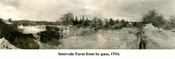
Intervale Farm from the by-pass. |
November 25, 1934 |
Yes |
Yes |
|
The by-pass at Intervale Farm. |
November 25, 1934 |
Yes |
No |
|
|
|
|
|
By-pass bridge at Emerson Hospital. |
April, 1935 |
Yes |
No |
|
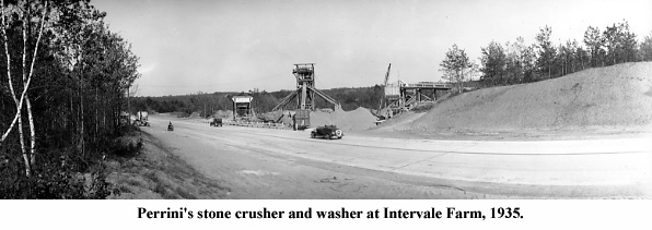
Perrini’s stone crusher and washer at Intervale Farm, No.1. |
June, 1935 |
Yes |
Yes |
|
Perrini’s stone crusher and washer at Intervale Farm, No.2. |
June, 1935 |
Yes |
Yes |
|
Perrini’s fleet of concrete mixers, Intervale Farm. |
June, 1935 |
Yes |
Yes |
|
|
|
|
|
Down river from the by-pass bridge at Emerson Hospital. |
March 15, 1936 |
Yes |
Yes |
|
Lowell Road, looking toward town from Red Bridge (Power House chimney at right center). |
March 15, 1936 |
Yes 2 |
Yes |
|
Lowell Road and Red Bridge from Hudson’s Meadow. |
March 15, 1936 |
Yes |
Yes |
|
Nashawtuc Road from the Bridge. |
March 15, 1936 |
Yes |
No |
|
Red Bridge from corner of Lowell Road and Liberty Street. |
March 15, 1936 |
Yes |
Yes |
|
The River between the Old South Bridge and Elm Street Bridge. |
March 15, 1936 |
Yes |
Yes |
|
Wright’s Bridge on the Fitchburg Turnpike at Nine Acre Corner. |
March 15, 1936 |
Yes |
Yes |
|
Looking toward the road to Sudbury from Fitchburg Turnpike at Nine Acre Corner. |
March 15, 1936 |
Yes |
Yes |
|
Looking west on Fitchburg Turnpike at Nine Acre Corner. |
March 15, 1936 |
Yes |
No |
|
Nine Acre Corner from Wright’s Bridge. |
March 15, 1936 |
Yes |
No |
|
The upriver side of Flint’s Bridge, Monument Street. |
March 21, 1936 |
Yes |
No |
|
Looking downriver from Nashawtuc Bridge. |
March 21, 1936 |
Yes |
Yes |
|
The Minute Man. |
March 21, 1936 |
Yes |
Yes |
|
Sudbury Road causeway looking toward Concord from Heath’s Bridge. |
March 21, 1936 |
Yes |
No |
|
Causeway looking toward Concord from Heath’s Bridge. |
March 21, 1936 |
Yes |
No |
|
Assabet River Bridge, near the Reformatory. |
March 31, 1936 |
Yes |
No |
|
Looking toward Concord on Walden Road from southerly side of by-pass. |
August 9, 1936 |
Yes |
Yes (2 copies) |
|
Sam Hoar’s Pond, Fairyland, the Town Forest, looking toward the outlet (the Dam). |
August 9, 1936 |
Yes |
Yes |
|
Sam Hoar’s Pond, Fairyland Pond, The Town Forest, looking toward Goose Pond. |
August 9, 1936 |
Yes |
Yes 2 |
|
Looking toward Concord on Walden Road from southerly side of by-pass. |
August 9, 1936 |
Yes |
Yes |
|
Looking up Brister’s Hill, before relocating Walden Road 100 feet to right. |
August 9, 1936 |
Yes |
Yes |
|
Corner of Thoreau Street and Walden Road, looking up Brister’s Hill toward Concord. |
August 9, 1936 |
Yes |
Yes |
|
|
|
|
|
Near Walden Breezes. New location of Walden Road is on the left of the electric wire poles. |
September 18, 1937 |
No |
Yes |
|
Near Walden Breezes, looking toward Lincoln. |
September 18, 1937 |
Yes 3 |
Yes |
|
Walden Road, looking toward Concord from near the State Police Barracks. |
September 18, 1937 |
Yes 2 |
Yes |
|
Walden Road, relocated, will be at the left of the poles. |
September 18, 1937 |
Yes 2 |
Yes |
|
Walden Road, relocated, will lie at left of poles (different view). |
September 18, 1937 |
Yes |
No |
|
Walden Road, looking toward Concord. Relocated (will be at right of poles). |
September 18, 1937 |
Yes 2 |
No |
|
Walden Road, looking toward Concord from near the State Police Barracks. |
September 18, 1937 |
No |
Yes |
|
Walden Breezes. |
September 18, 1937 |
Yes |
Yes |
|
Old State Police Barracks and Concord/Lincoln bound stone. |
September 18, 1937 |
Yes |
No |
|
Walden and Hubbard Streets. (Marion Barker house to be razed for new Post Office). |
September 18, 1937 |
Yes |
Yes |
|
Walden Road looking toward Concord from Site of Pest House. |
September 18, 1937 |
No |
Yes |
|
Site of the old Pest House. Walden Road, relocated, will be at the right of the poles. |
September 18, 1937 |
Yes |
Yes |
|
Site of Pest House, Walden Road. Relocated road will be directly over old cellar hole. |
September 18, 1937 |
Yes |
Yes |
|
|
|
|
|
Pine Street Bridge. |
November 24, 1940 |
Yes |
No |
|
Pine Street causeway and bridge. |
November 24, 1940 |
Yes |
Yes |
|
Assabet River meadows between R.R. and Pine Street Bridges. |
November 24, 1940 |
Yes |
No |
|
Assabet River meadows, upstream from Cousins’ Greenhouse. |
November 24, 1940 |
Yes |
No |
|
Assabet River meadows between Main Street and R.R. bridges. |
November 24, 1940 |
Yes |
No |
|
Assabet River meadows below Westvale Bridge. |
November 24, 1940 |
Yes |
No |
|
Assabet River meadows, downstream from Cousins’ Greenhouse. |
November 24, 1940 |
Yes |
No |
Series II: Sudbury and unknown location, undated.
|
Image descriptor |
Date |
|
|
|
Site of Parmenter Garrison, Sudbury. |
Undated |
Yes |
Yes |
|
Stone from Parmenter Garrison, Sudbury. |
Undated |
Yes |
Yes |
|
Old Town Bridge stone marker, Sudbury. |
Undated |
Yes |
Yes |
|
Scene of Indian battle in Sudbury During King Philip’s War |
Undated |
Yes |
Yes |
|
Unidentified photo |
Undated |
Yes |
Yes |
c2014 Concord Free Public Library, Concord, Mass.
Not to be reproduced in any form without permission of the Curator of the William Munroe Special Collections, Concord Free Public Library.
Back to the Special Collections homepage
Mounted 21 April, 2014. rcwh.