Oversized Concord, Massachusetts, Plan and Map Collection, 1754-1994
Vault A50, Unit 8
 Extent: 65 items, some consisting of multiple sheets.
Organization: Organized in two series. SERIES I: Plans, 1900-1990; SERIES II: Maps, 1754-1994. Each series is arranged into subseries.
Scope and Content: An artificial collection of large format plans and maps, 1754-1994, relating to Concord, Massachusetts. Series I consists of plans, including building plans of the Trinitarian Congregational Church (1925-1966), the First Parish in Concord (1933-1961), the Concord Free Public Library (1933-1990), the Concord Town Hall (1928-1930), Concord Bicentennial plans (1974-1975), and several other site plans. Series II consists of maps, primarily of Concord (1794-1994), including town lines, roads, bridges, and railroad alterations (1839-1975), maps of the Sleepy Hollow and Main Street Burying Grounds (1888-1934), and several Massachusetts maps (1926-1962).
Sources of Acquisition: Multiple; mainly undocumented.
Notes/Comments: Collection was developed by Special Collections staff. It contains many items that mesh with other CFPL collections, but are too large to accommodate with other archival materials.
Related Materials: These oversized maps and plans overlap with a number of organic collections of records and papers in the CFPL (for example, records of the First Parish Church, the Trinitarian Congregational Church, and the Concord Free Public Library). Consult finding aids on the CFPL website and staff of the Special Collections for more information.
Processed By: Shawna Smith, July 2009.
Container List
Series I. Plans of Concord, 1900-1990:
Subseries A: Building plans :
Box 1, Slot 1:
Trinitarian Congregational Church (1924). Pencil drawing of inside of chapel. Prepared by Frohman, Robb, and Little, Architects
Box 1, Slot 2:
Trinitarian Congregational Church plans (1925). Four sheets, including three photocopies of original plans; one of “the Galleries” two of the “Basement plans;” the final sheet is an original drawing of the first floor framing plans on a transparency sheet. Prepared by Frohman, Robb, and Little, Architects.
Box 1, Slot 3:
Trinitarian Congregational Church plans (1925). Five sheets, including photocopies of the original plans; basement, the first floor, the galleries, the north elevation, and the south elevation. Prepared by Frohman, Robb, and Little, Architects.
Box 1, Slot 4:
Trinitarian Congregational Church plans (1925-1930). Original plan of steeple; also plan of repairs to be made in the steeple. This work was completed in the spring of 1956. Frohman, Robb, and Little, Architects.
Box 1, Slot 5:
Trinitarian Congregational Church plans (1954). Three drawings signed by H. P. Aldrich and stamped by Frank Sewall Owen, Architect. Three drawings, including basement plans; first floor plans; and second floor plans. There is a note to Mr. Owen along with some notes written in pencil on the drawings.
Box 1, Slot 6:
Plan of Trinitarian Congregational Church (1954). This one sheet copy shows the elevation of the church. Survey by MacCarthy Engineering Service, Inc.
Box 1, Slot 7:
Trinitarian Congregational Church plans (1954). Thirty Sheets (numbered 1-20), include some duplicates kept for legibility. Plans by Frank Sewall Owen. Donated in 1984.
Box 1, Slot 8:
Trinitarian Congregational Church plans (1954). Two sheets, both copies of same drawing. Sketch of building locations. Surveyed by MacCarthy Engineering Service, Inc.
Box 1, Slot 9:
Trinitarian Congregational Church plans (1955). Includes four blueprints, three transparencies, and one paper drawing. Drawings are of church and new steeple.
Box 1, Slot 10:
Trinitarian Congregational Church plans (1955). Includes six drawing plans; basement, first floor, and second floor plans. Three are the originals and three are copies. Prepared by Frank Sewall Owen.
Box 1, Slot 11:
Trinitarian Congregational Church plans (1955). “Beetle Control Work,” including one blueprint containing measurements, one transparency drawing of the outside of the building, and one copy of the 1925 plan of the first floor with handwritten notes and measurements added.
Box 1, Slot 12:
Trinitarian Congregational Church plans (1955). Twenty-one original manuscript drawings by Frank Sewall Owen. Numbered 1, 1-A, 2-20. Includes plot plan, plans of the basement, first floor, second floor, elevation, new wings, etc.
Box 1A, Slot 1:
Trinitarian Congregational Church plans (1964). Proposed chapel addition by Frank Owen and Hugo Olson. Sixteen sheets include eight original manuscript drawings and eight copies of those drawings with some notes written on them.
Box 1A, Slot 2:
Trinitarian Congregational Church plans (1964). Eight drawings include two copies of the plot plan, two copies of the elevation, and two copies of the first floor plan, one copy of the outside of the church and one manuscript drawing on a transparency of the front of the church. The manuscript was repaired and housed in Mylar.
Box 1A, Slot 3:
Trinitarian Congregational Church plans (1966). Landscaping plans include five sheets; three original manuscripts and two copies. Sketches done by Weston Nursery, Inc.
Box 1A, Slot 4:
Trinitarian Congregational Church plans [undated]. Six drawings (three original manuscript plans and one copy of each). There are some handwritten notes on the copied pages.
Box 1A, Slot 5:
First Parish in Concord plans (1955). Manuscript drawings, blueprints, and copies.
Box 1A, Slot 6:
First Parish in Concord plans (1955). Manuscript drawings by Charles G. Loring, Architect. Two sheets depict the elevation.
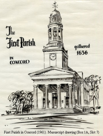
Box 1A, Slot 7:
First Parish in Concord (1961). Manuscript drawing of the church in ink (tracing from which a wood-cut was made). “To JWBallou 5/8/61.”
Box 1A, Slot 8:
Plan of the land belonging to the Estate of Helen A. Blanchard (1921). One manuscript canvas drawing. Signed Leonard C. Robinson, Eng’r, Concord, Mass.
Box 2, Slot 1:
Concord Free Public Library (1933). Copies of fourteen sketches of plans. Numbered 1-11 and 13-15 (12 is missing). Frohman, Robb and Little, Architects.
Box 2, Slot 2:
Concord Free Public Library (1933). One blueprint of the balcony railing, adult reading room. Some handwritten notes appear on sheet. Frohman, Robb and Little, Architects.
Box 2, Slot 3:
Concord Free Public Library (1985). Two sheets, copies of land survey done by Joseph Marcklinger.
Box 2, Slot 4:
Concord Free Public Library (1985). One plastic sheet, printed in black ink. Perry, Dean, Rogers & Partners.
Box 2, Slot 5:
Concord Free Public Library (1985, revised 1986). Thirty-seven sheets, copies of library addition and renovation. Top sheet is a table of contents for all drawings. Architect: Perry, Dean, Rogers & Partners; Structural Engineer: Thomas Rona Associates; Mechanical/Electrical Engineer: B R + A Consulting Engineers; Plumbing/Fire Protection Engineer: R. W. Sullivan, Inc.
Box 2, Slot 6:
Concord Free Public Library (1990-1992). Eight sheets, including two sets of identical copies of the West Concord Fowler Branch plans by J. H. Anderson, Architect (six sheets in total) and two sheets by David Holdorf, Architect of Schematic Designs; also copies of originals.
Box 2, Slot 7:
Stadia survey of Town House lot (1928). One sheet by Leonard C. Robinson. Brown paper with black ink and colored markings.
Box 2, Slot 8:
Rose Hawthorne Development (1978). Seven sheets, all copies of originals. Including one sheet map of the plan of the land, two sheets by E. M. Carlhian (phase 1 and phase 2), four sheets by Hammer, Kiefer and Todd, Architects and Planners.
Box 2, Slot 9:
Contour plan of portion of the estate of Herbert D. Hale, Arch’t, Concord, Mass. (1900). One blueprint sheet.
Box 2, Slot 10:
Wright Tavern plans (1944). Four blueprints and a draft letter to Mr. Russell W Wheeler. Blueprints include existing first floor, existing second floor, and second floor sketches.
Box 2, Slot 11:
Wright Tavern Plans (1962). Six copied sheets labeled 1-6, each signed. Including map location by Robert Lanchester, first floor plan by Robert Lanchester, second floor plan by Charles H. Brittain, third floor plan by Alan R. McDonald, east elevation by Robert Lanchester, south elevation by Robert Lanchester.
Box 2, Slot 12:
Unknown building plan of basement [undated]. Some handwritten markings on the single unlabeled blueprint sheet.
Subseries B: Other site, facility, and event plans:
Box 3, Slot 1:
Plan of the Walden Woods (1895). Photocopied plan of Walden Woods in Concord and Lincoln. Surveyor Albert E. Woods. Copy is difficult to read.
Box 3, Slot 2:
1975 Celebrations Committee. Plan of Monument Square. Produced by J. Walter Brain, Landscape Architect. Two duplicate copies.
Box 3, Slot 3:
1975 Celebrations Committee. Floor plans of Concord Armory, seating plans for luncheon, and decorating motif. Produced by Town of Concord Engineering Division. Five sheets.
Box 3, Slot 4:
1975 Celebrations Committee. Two maps showing plans for bus routes, parking, and traffic routing; and first aid and sanitary locations.
Series II: Maps, 1754-1994:
Subseries A: Concord maps, 1754-1994:
Box 3, Slot 5:
Plan for a monument at the battle ground on land given by Ezra Ripley (1835). Photostat from original manuscript.
Box 3, Slot 6:
North part of Concord, or District of Carlisle (1754). Two photocopies of the original. Benj. Brown, surveyor.
Box 3, Slot 7:
Plan of the Town of Concord (1794). Photocopy from original. Ephraim Wood, surveyor.
Box 3, Slot 8:
Walling map of Concord (1852). “From Prescott Keyes Auction, June 3, 1944.” One canvas scroll.
Box 3, Slot 9:
Walling map of Concord (1852). One canvas scroll.
Box 3, Slot 10:
Map of Concord/Acton town line and “disputed ground” (1868). One small map.
Box 3, Slot 11:
Map of the Town of Concord and Carlisle (1903). Copy made by Morse Payne, 1996. Payne added some boundary lines.
Box 3, Slot 12:
Map of Concord (1922). Handwritten map of roads and town lines.
Box 4, Slot 1:
Traffic flow map for the Town of Concord (1936). Two duplicate prints of map. Department of Public Works W. P. A. Traffic Census. Project No. 65 14-9792.
Box 4, Slot 2:
Map of the Town of Concord (1942). Surveyed 1937 and 1941. Prepared for the Concord Planning Board for aerial photographs by the Institute of Geographical Exploration Harvard University. One sheet (paper).
Box 4, Slot 3:
Map of the Town of Concord (1942). Surveyed 1937 and 1941. Prepared for the Concord Planning Board for aerial photographs by the Institute of Geographical Exploration Harvard University. Wooded areas plotted by A. H. Hepburn in 1942. One sheet (canvas).
Box 4, Slot 4:
Map of the Town of Concord (1942). Surveyed 1937 and 1941. Prepared for the Concord Planning Board for aerial photographs by the Institute of Geographical Exploration Harvard University. One enlarged copy on paper .
Box 4, Slot 5:
Composite maps of Concord (1946). Prepared by Planning Board, Concord. Map shows Sections 12, 16, 17, 19, & 20 or parts thereof with gross land elevations indicated. B. I. Makepiece, Inc., Boston, Mass. exclusive licensee. Five sheets (plastic).
Box 4, Slot 6:
Overlay maps of the Town of Concord (1958). Three color manuscript sheets include; one of the facilities, one of the waterlines, and one of the sewage system. Each is taped to cardboard, possibly for display use.
Box 4, Slot 7:
Map of Town of Concord (1979). Bedrock geology, compiled by Patrick J. Barosh. One large printed sheet showing the intrusive rocks found in Concord.
Box 4, Slot 8:
Redistricting (1994). One printed sheet, including some original manuscript, mapping out the polling places for the precincts of Concord.
Box 4, Slot 9:
Map of Concord [undated]. Manuscript map in the shape of the town’s outlines. Map in several pieces.
Box 4, Slot 10:
Flood Conservancy District Map [undated]. Map of the Town of Concord with some original manuscript and color coding of plan. Some water damage to bottom right corner of map.
Box 4, Slot 11:
Map of parts of Nashawtuc Farm and vicinity (1925). Showing lands conveyed by William Wheeler to Berkeley Wheeler by deed of May 20, 1925. Two sheets include one canvas drawing and one in black ink on paper in actual shape of area. An accompanying photocopy map of Nashawtuc from 1976.
Box 4, Slot 12:
Map of upper Main Street [undated]. Original manuscript outlining property lines. One sheet (canvas).
Subseries B: Roads, bridges, and railroads; 1839-1975:
Box 5, Slot 1:
Proposed bridge over the Concord River (1839). One sheet, original watercolor sketch of bridge and its proposed dimensions.
Box 5, Slot 2:
Plan of alteration of roads in Concord (1856). As laid out by order of the County Commissioners. Swan and Straw C. [Civil] Engr’s, Lowell, Mass. One manuscript drawing (canvas) of roads in Concord.
Box 5, Slot 3:
Proposed extension of the Middlesex Central Railroad (1878). Original manuscript sketch of railroad and proposed dimensions, signed by R. E. Woodward, Civil Engineer.
Box 5, Slot 4:
Alternative routing for Route 2 (1975). Eight sheets of manuscript drawings depicting Route 2 (on grid paper). Alternatives are labeled 1-8.
Subseries C: Cemeteries in Concord, 1888-1934:
Box 5, Slot 5:
Sleepy Hollow Cemetery (1888). Nine copies of the plot layout, surrounding estates, and roads. Ernest W. Bowditch, Landscape Gardener.
Box 5, Slot 6:
Map of Main Street Burying Ground (1934). Original manuscript drawings mapping out the cemetery plots. Map is damaged and taped to heavy paper.
Subseries D: Other Massachusetts maps, 1926-1962:
Box 5, Slot 7:
Route map of Massachusetts (1926). Two copies of printed map of Massachusetts, depicting roads and highways, including those in Concord.
Box 5, Slot 8:
U.S. Geological Survey map of Boston and vicinity (1961). One printed sheet (color) depicting town lines, including those in Concord.
Box 5, Slot 9:
Map of Massachusetts city lines [undated]. Photocopy of hand drawn map of town lines, including those of Concord.
Box 5, Slot 10:
Map of downtown Boston (1962). One sheet produced by Boston Redevelopment Authority.
c2009 Concord Free Public Library, Concord, Mass.
Not to be reproduced in any form without permission of the Curator of Special Collections, Concord Free Public Library.
Mounted 29th July 2009. rcwh.