Concord Map Collection, 1775, 1830-<2006>
Vault B40, Unit 1
 Extent: ca. 299 maps, 3 books, 10 supplemental documents.
Arrangement: Arranged in nine series.
Series I: Town Maps
Series II: Time-Frame Composite Maps
Series III: Cemetery Maps
Main Street Burying Ground
New Hill Burying Ground
Sleepy Hollow
Series IV: Directories and Tourist Maps
Series V: Planning Maps
Series VI: Railroad Maps
Series VII: Revolutionary War History Maps
19th of April
Battle of Bunker Hill
Miscellaneous Revolutionary War Maps
Series VIII: Sanborn Fire Insurance Maps
Series IX: USGS Maps
Scope and Content: Collection consists of maps, plans, and guides, including topographical maps, cadastral maps, illustrated maps, and photomaps. Maps primarily depict Concord, Massachusetts, and its neighboring communities.
Known creators represented include Ackerman, Edward A. (Edward Augustus), 1911- ; Altshuler, Suzanne; Appalachian Mountain Club. Boston Chapter; Applied Geographics, Inc.; Banister, John; Beers, F. W. (Frederick W.); Bissell, H.; Blaisdell, Hiram W.; Blanchard, Roberta R.; Bodley, H.; Bowditch, Ernest W.; Bowker, Ed; Brown, Benjamin; Brown, Merrill A.; Brown, W. T.; Cabot, Chilton; Caswell, William W.; Chamberlain, A. P.; Chisholm, Ivan A.; Clark, S.; Community Phonebook Company; Concord Chamber of Commerce (Mass.); Concord Journal; Concord (Mass.). Cemetery Committee; Concord (Mass.). Dept. of Natural Resources; Concord (Mass.). Dept. of Public Works; Concord (Mass.). Engineering Dept.; Concord (Mass.). Historic Districts Commission; Concord (Mass.). Planning Board; Concord (Mass.). Zoning Board; Comey, Arthur C. (Arthur Coleman), 1886-1954; Dabrowski, Richard A.; Dee, Charles W.; Eddy; Emerson, R.; Fagan, James O.; Farrell, D. F.; Fenn, Mary Gail; Ferran, Arch; Forman, Richard T. T.; Gadoury, Russell A.; Gannett, C. H.; Garfield, Alva Scott; Geological Survey (U.S.); George H. Walker & Co.; Gleason, Herbert Wendell, 1855-1937; Goldberg, S; Hales, John Groves; Harvard University. Institute of Geographical Exploration; Harvard University. Museum of Comparative Zoology; Hatch, Mary Jaquelin; Hayes, H. W.; Heritage Cartography (Firm); Hosmer, Stephen; Howard, Harold; Hubbard, Cyrus, 1791-1865; Hubbard, Winfred D.; Interstate Publishing Co. (Everett, Mass.); Jameson, Bill; Jarvis, Edward, 1803-1884; Junior League of Boston; Jones, Edward A.; Joslin, Elmer; Koteff, Carl; League of Women Voters of Concord-Carlisle; LeBaron; Lieder, C.; Maguire Group; Metcalf, Leonard, 1870-1926; Mills, Charles; Montague, E. N.; Morgan, R. A.; Nelson, A; New England Orienteering Club; Owen, F. S.; Patel, U. T.; Perley, David W.; Peters, A. C.; Petersen, Richard G. (Richard Gray), 1928-; Pollack, S. J.; Preble, Frank L.; Rice, Reuben; Robinson, Leonard C.; Roman, John; Sanborn Map Company; Sanborn-Perris Map Co.; Shattuck, Lemuel, 1793-1859; Silverberg, Constance Rice; Smith, Whitney S.; Stickney, Frank W.; Stock, Ernest R.; Stromeyer, M.; Thoreau, Henry David, 1817-1862; Tuttle, William D.; U.S. Fish and Wildlife Service; United States. Government Printing Office; Voight, Charles R.; Walling, Henry Francis, 1825-1888; Warner; Wetherill, Kent; Wheeler, Ruth Winifred Robinson, 1890-1973; Wheeler, William; Wood, Albert E.; Wood, G. K. (George K.); and Wood, James Barrett.
Source of Acquisition: Many, largely undocumented.
Processing: Processed by Christina Tanguay. Finding aid completed April 2012.
Series I. Town Maps, 1830 – <2002>.
Extent: ca. 190 maps, 1 book, 6 supplemental documents.
Arrangement: Chronological by date depicted.
Scope and Content: Collection consists of maps, plans, and guides, including topographical maps, cadastral maps, and photomaps. Includes maps depicting land and land use including zones, streets, and natural features. Maps primarily depict Concord, Massachusetts, and its neighboring communities.
Known creators represented include Ackerman, Edward A. (Edward Augustus), 1911-; Appalachian Mountain Club. Boston Chapter; Applied Geographics, Inc.; Banister, John; Beers, F. W. (Frederick W.); Blaisdell, Hiram W.; Blanchard, Roberta R.; Brown, Benjamin; Brown, W. T.; Bodley, H.; Chamberlain, A. P.; Community Phonebook Company; Concord (Mass.). Dept. of Natural Resources; Concord (Mass.). Engineering Dept.; Concord (Mass.). Historic Districts Commission; Concord (Mass.). Planning Board; Concord (Mass.). Zoning Board; Comey, Arthur C. (Arthur Coleman), 1886-1954; Emerson, R.; Fenn, Mary Gail; Forman, Richard T. T.; Gannett, C. H.; George H. Walker & Co.; Gleason, Herbert Wendell, 1855-1937; Hales, John Groves; Harvard University. Institute of Geographical Exploration; Harvard University. Museum of Comparative Zoology; Hubbard, Winfred D.; Hosmer, Stephen; Howard, Harold; Hubbard, Cyrus, 1791-1865; Interstate Publishing Co. (Everett, Mass.); Jameson, Bill; Jarvis, Edward, 1803-1884; Jones, Edward A.; Joslin, Elmer; League of Women Voters of Concord-Carlisle; LeBaron; Lieder, C.; Maguire Group; Metcalf, Leonard, 1870-1926; Mills, Charles; Montague, E. N.; New England Orienteering Club; Patel, U. T.; Perley, David W.; Peters, A. C.; Preble, Frank L.; Rice, Reuben; Robinson, Leonard C.; Roman, John; Shattuck, Lemuel, 1793-1859; Stickney, Frank W.; Thoreau, Henry David, 1817-1862; Tuttle, William D.; U.S. Fish and Wildlife Service; Walling, Henry Francis, 1825-1888; Warner; Wheeler, Ruth Winifred Robinson, 1890-1973; Wheeler, William; and Wood, Albert E.
Location: Drawers 1-3.
Item List
Drawer 1:
16--.1 Seventeenth Century Settlers, undated. Scale 1:9,600. Shows locations of homes and town buildings in Concord during the seventeenth century, includes names of landowners. 8.5 x 14 in.
Drawer 1:
1635/56.1 Our American Mile: Concord’s Battle Road, the Nation’s Most Significant Historic Site, undated, by Ruth R. Wheeler. Scale 1:28,800. Shows roads and residences from 1635 to 1656, includes names of landowners. 9 x 12 in.
Drawer 1:
1635/56.2 Draft of map from Our American Mile: Concord’s Battle Road, the Nation’s Most Significant Historic Site, undated, by Ruth R. Wheeler. Scale 1:28,800. Shows roads and residences from 1635 to 1656, includes names of landowners. 8.875 x 12.75 in.
Drawer 1:
1635/1928.1a A Map of Concord, The Old Musketaquid Plantation, 1928. Drawn by H. Bodley. Printed by Houghton Mifflin Company. Scales vary. Shows detailed images and locations of important sites in Concord in 1928. Inset map of Concord in 1635. Includes inset illustrations of various Concord buildings. Color illustrations. Inscribed by H. Bodley to the Concord Library. 28 x 37 in.
Drawer 1:
1635/1928.1b A Map of Concord, The Old Musketaquid Plantation, 1928. Drawn by H. Bodley. Printed by Houghton Mifflin Company. Scales vary. Shows detailed images and locations of important sites in Concord in 1928. Inset map of Concord in 1635. Includes inset illustrations of various Concord buildings. Color illustrations. Map is very fragile and has some damage. Stored at bottom of drawer, out of chronological order, to minimize handling. 28 x 37 in.
Drawer 1:
1655.1 Concord in 1655 immediately after the “Second Division” of Land, probably circa 1955. By R.T.T. Forman. Reproduced from Historic Resources Masterplan of Concord, Massachusetts, 1955. Scale 1:23,760. Shows the establishment of three sections within Concord: North Quarter, East Quarter, and South Quarter. 18 x 23.25 in.
Drawer 1:
1655.2 Land Desired by Billerica, 1655. Undated facsimile. Shows land petitioned for by Billerica from Chelmsford and Concord and locations of several farms. Original located at Massachusetts State Archives. 14.25 x 20.75 in.
Drawer 1:
1660/1823.1 Map of Littleton, after 1823. Reproduced, 1935. Shows properties and boundaries, partially shows Concord Village circa 1660. Includes notations about changes in Littleton up until 1823. Original located at the Littleton Historical Society. 21.3125 x 22 in.
1684.1 Dividing Line between Cambridge and the farms adjoining Concord, 1684. Undated facsimile. Includes surveyor’s notes. Original located at the Massachusetts State Archives. 15 x 15.5 in.
Drawer 1:
1686.1 Map of Littleton, 1686. Undated photo duplication. Shows boundary with Concord Towne, Chelmsford, Groton, and Nashoba Plantation. Includes surveyor’s notes. Original located at the Massachusetts State Archives. 12.5 x 15.75 in.
Drawer 1:
1715.1 Line between Concord and Stowe, 1715. Undated facsimile. Drawn by John Banister. Includes letter from Banister regarding survey. Original located at Massachusetts State Archives. 13.25 x 18.875 in.
Drawer 1:
1715.2 Line between Concord and Stowe, 1715. Undated facsimile. Drawn by John Banister. Includes letter from Banister regarding survey. Differs from 1715.1. Original located at Massachusetts State Archives. 12.25 x 15.375 in.
Drawer 1:
1754.1 Easterly Part of Old Concord – Set off in 1754 to Lincoln, undated. Undated photocopy of a drawing of a map located at the Lincoln Public Library. Shows land that later became a part of Lincoln in 1754. 8.5 x 14 in.
Drawer 1:
1754.2 Map of (the District of) Carlisle, 1754. Undated facsimile. Drawn by Stephen Hosmer. Original located at the Massachusetts State Archives. Shows names of landowners. 17.5 x 20.75 in.
Drawer 1:
1754.3 North Part of Concord (or “District of Carlisle”), 1754. Undated facsimile. Drawn by Benjamin Brown. Shows Concord’s North Quarter. Partial cadastral map showing names of landowners. Original located at the Massachusetts State Archives. 2 copies. 14 x 18 in.; 14.75 x 18 in.
Drawer 1:
1754.4 North Part of Concord (or “District of Carlisle”), 1754. Drawn by Benjamin Brown. Undated reproduction from the Massachusetts State Archives. Shows Concord’s North Quarter. Partial cadastral map showing names of landowners. Overwritten annotations in red ink showing street names and houses mentioned in Wheeler House File. Includes supplemental copy of notes from the Wheeler house file. Map: 12.25 x 15.125 in.; Supplement: 8.5 x 11 in.
Drawer 1:
1754.5 Tracing of North Part of Concord (or “District of Carlisle”), 1945. Photocopy of a drawing by Ruth R. Wheeler. From a photostat of an original map by Benjamin Brown, 1754. Shows Concord’s North Quarter. Original located at the Massachusetts State Archives. 8.5 x 11 in.
Drawer 1:
1775, See also Revolutionary War History Maps.
Drawer 1:
1775.1 Concord in 1775 at the time of the Minute Men and British Skirmish, 1995. By R.T.T. Forman. Undated reproduction from Historic Resources Masterplan of Concord Massachusetts. Scale 1: 23,040. Includes notes on the borders of Concord. 17.875 x 22.5 in.
Drawer 1:
1775/1875.1 Centennial Map of Concord, 1775 – 1875, 1875. Drawn by H. W. Blaisdell. Scale 1:6,000. Shows buildings in Concord Center circa 1775 and 1875, and military movements from April 19, 1775. British retreat marked in colored ink. 12 copies (1 matted). Originals: 13.75 x 18 in.; 14 x 22 in.; 16 x 21.5 in.
Drawer 1:
1779.1 Map of Carlisle, 1779. Undated facsimile. Partial cadastral map. Shows boundaries of Carlisle and names of landowners. 12.5 x 15 in.
Drawer 1:
1794.1 Map of Concord, 1794. Undated facsimile. Drawn by Ephraim Wood. Oriented with North to the lower right. Original located at the Massachusetts State Archives. 3 copies. 14.25 x 19.5 in.; 11.75 x 17.75 in.; 11.5x17.25 in.
Drawer 1:
1810/20.1 Map of Concord, Mass Central Village as it was 1810 to 1820 and Profile of the Mill Dam, 1883. Undated hand drawn copy of original drawing by Edward Jarvis. Scales differ. North oriented to the right. Shows locations of buildings and businesses. Includes index to buildings at the Mill Dam. Original located at the Concord Free Public Library, William Munroe Special Collections. 10.75 x 9.25 in.
Drawer 1:
1810/20.2 Concord Milldam Shops 1810-1820, 1971. Undated photocopy. Redrawn by T. Reed based on a map by Dr. Edward Jarvis appearing in Houses and People of Concord. Scale 1:480. Shows location of houses and businesses. 8.5 x 11 in.
Drawer 1:
1810/20.3 Concord Village 1810 -1820, 1971. Undated photocopy. Redrawn by T. Reed based on a map by Dr. Edward Jarvis appearing in Houses and People of Concord. Scale 1:2,400. Shows location of houses and businesses. Original located at the Concord Free Public Library, William Munroe Special Collections. 8.5 x 11 in.
Drawer 1:
1830.1 Plan of the Town of Concord in the County of Middlesex, 1830. Drawn by John G. Hales. Published by Lemuel Shattuck, Boston. Scale 1:19,800. Shows roads, churches, landowners, and land features. Annotation made on map in red ink. 2 original, 3 reproductions. Originals: 19.75 x 23.5 in.; 19 x 23 in.; Reproductions: 19.5 x 23.5 in. (2); 17.5 x 21 in.
Drawer 1:
1830.2 Plan of the Town of Concord in the County of Middlesex, 1830. Undated photoreproduction. Drawn by John G. Hales. Scale ca. 1:24,369. Shows roads, churches, landowners, and land features. Differs from 1830.1. Original located at the Massachusetts State Archives. 2 copies. 16.25 x 23 in.; 16 x 22 in.
Drawer 1:
1835.1 Map of land donated to Concord by Rev. D. D. Ezera Ripley for an April 19, 1775 memorial, February 23, 1835. Undated negative photostat. Cadastral map. Drawn by Cyrus Hubbard. Shows the land donated by Ezra Ripley for the Concord Minuteman Statue including a lane leading to the proposed monument in relation to Monument Street and the Concord River. 13.938 x 16.75 in.
Drawer 1:
1845.1 Henry David Thoreau’s Concord Mass circa July 4th 1845, 2006. Drawn by John Roman. Bird’s eye view. Scales vary. Shows a view of Concord from Fair Haven Hill. Inset drawings of Thoreau homes and other locations. Supplemental documentation includes a list of historic facts depicted in the map, and a thank you letter from John Roman to Leslie Perrin Wilson regarding historical research. 2 copies. Maps: 20 x 30 in.; Supplements: 8.5 x 11 in, 1 page each.
Drawer 1:
1846.1 Survey of Walden Pond, 1846. Facsimile, 1954. Drawn by Henry D. Thoreau. Collotype published by Charles E. Goodspeed & Co., Boston. Scale 1:1,980. North oriented toward the bottom. Original located at the Concord Free Public Library, William Munroe Special Collections. 21 x 25 in.
Drawer 1:
1848.1 Plan of a Lot of Pasture and Woodland in Concord belonging to Hon. F. R. Gourgas bought of Josiah Buttrick, 1848. Drawn by S. Davis. Scale 1:1,584. Shows lot of land adjacent to Bridle Way and Carlisle Road. 17.438 x 21.5 in.
Drawer 2:
1850.1 Map of Concord about 1850, circa 1962. Undated photoreproduction. Drawn by U. T. Patel. Appears in August Derleth’s Concord Rebel: A Life of Henry David Thoreau, 1962. Shows main roads and some natural features mentioned by Thoreau in his writings. 8.5 x 11 in.
Drawer 2:
1850/60.1a Map of Concord, Mass. Showing Localities Mentioned by Thoreau in his Journals, 1906. Undated facsimile. Compiled by Herbert W. Gleason. Appears in 1906 Walden and Manuscript editions of The Writings of Henry David Thoreau. 19 x 20 in.
Drawer 2:
1850/60.1b Index to Map of Concord, 1906. Undated facsimile. Index to Herbert W. Gleason’s Map of Concord, Mass. Showing Localities Mentioned by Thoreau in his Journals. Appears in 1906 Walden and Manuscript editions of The Writings of Henry David Thoreau. Shows Concord as it appeared 17 x 20 in.
Drawer 2:
1850/60.1c Map of Concord, Mass. Showing Localities Mentioned by Thoreau in his Journals, 1906. Undated facsimile. Compiled by Herbert W. Gleason. Appears in 1906 Walden and Manuscript editions of The Writings of Henry David Thoreau. Contains index to locations. 18 x 23.75 in.
Drawer 2:
1850/60.1d Map of Concord, Mass. Showing Localities Mentioned by Thoreau in his Journals, 1906. Undated reproduction. Compiled by Herbert W. Gleason. Appears in 1906 Walden and Manuscript editions of The Writings of Henry David Thoreau. Contains index to locations. Scale ca. 1:38991. 2 copies. 13.75 x 18.5 in.
Drawer 2:
1850/60.1e Map of Concord, Mass. Showing Localities Mentioned by Thoreau in his Journals, 1906. Undated photocopy. Compiled by Herbert W. Gleason. Appears in 1906 Walden and Manuscript editions of The Writings of Henry David Thoreau. Contains additional notations marking the Boston and Maine Railways and the New York, New Haven, and Hartford Railways. 2 variations. 8.5 x 11 in.; 10.25 x 13 in.
Drawer 2:
1850/60.2 Thoreau’s Concord, 1944. Drawn by Roberta R. Blanchard. No scale given. Pictorial landmarks. Hand colored. Inscribed with a Christmas greeting from Harold and Roberta Blanchard. 8.5 x 11 in.
Drawer 2:
1850/60.3 Thoreau’s Easterbrook Country, 1970. Drawn by Mary Gail Fenn. Published by the Thoreau Society, Inc. Appears in Thoreau Society Booklet #25. Scale 1:9,386. Shows sites in Easterbrook Country as mentioned in Thoreau’s Journals. Contains an index of reference. 22 x 27.5 in.
Drawer 2:
1850/60.4 Thoreau’s Rivers, 1973. Drawn by Mary Gail Fenn. Published by the Thoreau Society, Inc. Appears in Thoreau Society Booklet #27. Shows the waterways and surrounding features of Concord, Lincoln, Sudbury, and Wayland as referenced by Thoreau’s journals. 4 copies. 24.5 x 24 in.
Drawer 2:
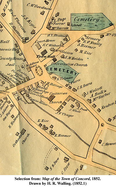
1852.1 Map of the Town of Concord, 1852. Drawn by H. R. Walling. Scales differ. Colored. Shows landowners and land features. Inset of Concord Center. 4 copies, 25.5 x 32.25 in.
Drawer 2:
1852.2 Map of the Town of Concord, Middlesex Co., Mass., 1852. Undated reproduction. Scale 1:31,680. Contains legend of natural features and significant locations. 15 x 18.25 in.
Drawer 2:
1856.1 Cutout Maps of Concord, 1856. Drawn by Henry F. Walling. Removed from Map of Middlesex County and mounted on paper. Scales differ. Colored. Shows buildings in Concord Center and residences. 8.5 x 16.875 in.
Drawer 2:
1856.2a Map of Concord Center, 1856. Undated photoreproduction. Drawn by Henry F. Walling, from his Map of Middlesex County. Scale ca. 1:4,659. Shows locations of businesses, municipal buildings, and homes. 14.5 x 17.75 in.
Drawer 2:
1856.2b Map of Concord Center, 1856. Photoreproduction, 1978. Reproduced by Peter Orlando from Henry F. Walling’s original map. 11 x 14 in.
Drawer 2:
1856.3 Map of Concord, 1856. Facsimile, 1978. Reproduced by Peter Orlando from Henry F. Walling’s original map. 11 x 14 in.
Drawer 2:
1856/73.1 Map of Concord, Concord Village and Westvale, between 1856 and 1873, Shows homes, buildings, and public spaces. Colored. Scales differ. Map is damaged. 14.75 x 24.5 in. in two pieces.
Drawer 2:
1859.1a-c A Plan of the State Encampment Concord, MA Sept. 7th, 8th, & 9th, Embracing, Key to Bachelder’s Picture of the Review, Sept. 9th 1859, 1859. Scale 1:1,800. Key to a bird’s eye view picture of the Concord Encampment. 2 originals, 3 photocopies. Original: 23 x 34.25 in.; Photocopies: 24 x 36 in.
Drawer 2:
1860.1 Plan of Nathaniel Hawthorne’s Estate in Concord, Mass., August 20, 1860. Reproduced, 1964. Drawn by Henry D. Thoreau. Shows the Wayside. 10.5 x 14.5 in.
Drawer 2:
1868.1 Plan of Peter Robins place in the East Part of Concord, 1868. Drawn by Reuben Rice. Scale 1:1,584. 11.25 x 19.75 in.
Drawer 2:
1874.1 Hubbard Estate Improvement Concord, Mass., about 1874. Drawn by Albert E. Wood. Cadastral map. Scale 1:1,920. Shows some property owners and a list of lots on Hubbard Street to be sold for development. 2 originals (one with additional handwritten notation), 1 photocopy. Originals: 17.5 x 23.75 in.; 14.625 x 23 in.; Photocopy: 16 x 23.75 in.
Drawer 2:
1874.2 Plan of Land at Concord Junction Belonging to Benjamin Derby, 1874. Cadastral map. Scale 1:1,920. Shows 109 lots of land along Derby, Westvale, Central, Prairie, and West Streets and Riverside Avenue. Notations made on map in pencil. 19.5 x 24 in.
Drawer 2:
1874.3 Plan of Land at Concord Junction belonging to Benjamin Derby, Concord, Mass, 1874. Undated photocopy. Cadastral map. Drawn by William Wheeler and H. W. Blaisdell. Original located at the Middlesex South District Registry of Deeds. 14.4 x 17 on 2 leaves.
Drawer 2:
1874.4 Plan of Land Taken of R. Warner by the State of Massachusetts and to be occupied by the New State Prison, 1874. Undated facsimile. Drawn by Brown and LeBaron. Shows a small portion of the Lowell and Framingham Railroad tracks. Original located at the Middlesex South District Registry of Deeds. 11 x 16 in.
Drawer 2:
1875 See also 1775/1875.1.
 Drawer 2:
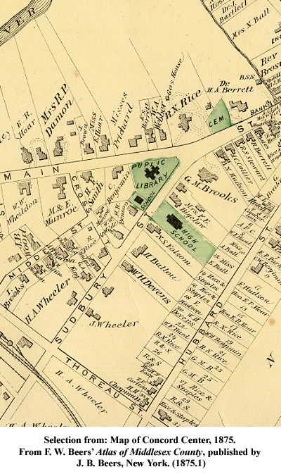
1875.1 Map of Concord Center, 1875. From F. W. Beers’ Atlas of Middlesex County, published by J. B. Beers, New York. Cadastral map. Scale 1:4,800. Colored. 15 x 20.25 in.
Drawer 2:
1875.2 Map of Concord and Westvale, 1875. From F. W. Beers’ Atlas of Middlesex County, published by J. B. Beers, New York. Scales differ. Colored. Shows buildings and land features. 1 original, 1 reproduction. Original: 11.5 x 15.75 in.; Reproduction: 11 x 17 in.
Drawer 2:
1875.3 Map of Concord with Inset of Westvale, undated. Reprinted by Mill Square Partnership and Press Works, Ltd. from F. W. Beers’ Atlas of Middlesex County, 1875, published by J. B. Beers, New York. Shows buildings and land features. Scales differ. Annotations made on map. Verso contains an index to historic sites of West Concord and histories of the Harrington House, “1775 House,” and Damondale Mill. 12.75 x 17 in.
Drawer 2:
1875.4 Plan of Land Belonging to William Munroe, Concord, September, 1875. Surveyed by Wheeler and Blaisdell. Scale 1:480.North oriented to the left. Colored. Shows land along Warren and Bow Streets. 17 x 22 in.
Drawer 2:
1875.5 Plan of Land Belonging to William Munroe, Concord, October, 1875. Surveyed by Wheeler and Blaisdell. Scale 1:480. North oriented to the right. Colored. Shows land along Main and Thoreau Streets. Also includes portion of Fitchburg Railroad tracks and car house. 15.75 x 21.25 in.
Drawer 2:
1875/96.1 Plan of Building Lots as Laid out by Ralph Warner at Concord Junc’n, November 1875 and May 1896. Undated photocopy. Drawn by William D. Tuttle. Cadastral map. Shows plots of land along Church, Main, and Highland Streets. Shows a portion of Fitchburg Railroad tracks. Scale indeterminable. Original located at the Middlesex South District Registry of Deeds. 10.25 x 15.5 in.
Drawer 2:
1884.1 Nashawtuc Hill Belonging to Estate of C. H. Hurd, Esq., Concord, Mass, February 29, 1884. Surveyed by William Wheeler. Drawn by Frank L. Preble. Cadastral map. Scale 1:2,400. Shows plots of land on Nashawtuc Avenue and Attawan Street. Names of homeowners added in pencil for homes along Elm and Main Streets. 16 x 22 in., in 2 pieces.
Drawer 2:
1889.1 1889 Map of Concord and Lincoln, undated. Facsimile. Published by George H. Walker & Company. Scale indeterminable. Colored. Shows roads, railways, waterways, and landowners. 17.75 x 22 in.
Drawer 2:
1889.2a Map of Concord and Westvale, 1889. Published by George H. Walker & Company. Scale 1:3,000. Colored. Shows land surrounding the Agricultural Fairgrounds and Nashawtuc Hill, inset of Main Street in Westvale. Partially obscured maps of Lincoln and Concord Junction on verso. Damaged. 17.625 x 28.5 in.
Drawer 2:
1889.2b Map of Concord and Westvale, 1889. Published by George H. Walker & Company. Undated incomplete photocopy. Scale 1:3,000. Shows land surrounding the Agricultural Fairgrounds and Nashawtuc Hill, inset of Main Street in Westvale. 16.25 x 26 in.
Drawer 2:
1889.3 1889 Map of Concord Center, 1889. Undated facsimile. Published by George H. Walker & Company. Scale indeterminable. Shows the buildings, roads, and waterways surrounding Concord Center and the Old North Bridge. 18 x 25 in.
Drawer 2:
1899/1914.1 Sketch Plan of Nashawtuc Farm & Vicinity, 1899 to 1914. Drawn by A. P. Chamberlain, Wheeler, and Warner. Blueprint. Shows plots of land surrounding Nashawtuc Hill. Contains notations in red pencil and a key of names. 17.125 x 23.25 in.
Drawer 2:
1893.1 Plan of Land and Building Lots near Concord Junction, Mass. Owned by Harvey Wheeler, April 1893. Undated photocopy. Shows plots of land along Cottage and Crest Streets and Road to Nine Acre Corner. North oriented to the lower left. Original located at the Middlesex South District Registry of Deeds. 9.875 x 15.75 in.
1893.2 Plan of Centre of Town of Concord, Mass., May 1893. Drawn by Albert E. Wood. Appears in the Concord Directory & Guide. Cadastral map. Shows ways, buildings, barns, and historic sites. 15 x 18.25 in.
Drawer 2:
1894.1 Plan of Micajah Rice Farm, Concord, Mass, September 1894. Undated photocopy. Drawn by Albert E. Wood. Cadastral map. Shows the boundaries of the Micajah Rice Farm and lists surrounding landowners. Original located at the Middlesex South District Registry of Deeds. 11 x 15 in.
Drawer 2:
1896 See also 1875/96.1.
Drawer 2:
1896.1 Map of Concord, Mass., 1896. Published by Edward A. Jones. Appeared in The Concord Directory. 18.5 x 21.5 in.
Drawer 2:
1896.2 Map of the Country Northwest of Boston, 1896. Published by the Appalachian Mountain Club, Boston. Topographical map. (W71°22’—71° / N40°31’— 40°20’) Colored. Shows streets, wooded areas, and public reservations. Portion of Concord is missing from the map. 12.75 x 19.5 in.
Drawer 2:
1896.3 Plan of Building Lots in Concord, Mass Owned by the Concord Junction Land Company, 1896. Undated photocopy. Cadastral map. North oriented to the left. Shows plots of land along Highland and Church Streets and County Road to Maynard. Original located at the Middlesex South District Registry of Deeds. 10.25 x 15.625 in.
Drawer 2:
1896.4 Plan of Northerly Part of Farm in Concord, Mass. Owned by Charles L. Hutchins, May 1896. Drawn by Albert E. Wood. Undated photoreproduction. North oriented to the right. Shows land located adjacent to Monument Street. 21.25 x 33 in.
Drawer 2:
1898.1 Map of Concord and Concord Junction, Mass, September 15, 1898. Drawn by F. L. Preble, from surveys by William Wheeler, Hiram W. Blaisdell, and Leonard Metcalf. Scale 1:4,800. 34 x 70 in. in 2 pieces.
Drawer 2:
1898.2 Plan of Road in Concord, Middlesex County, Locally Known as Lexington Road Laid out by the Massachusetts Highway Commission, September 1, 1898. Undated photocopy. Drawn by Charles Mills. North oriented to the right. Original located at the Middlesex South District Registry of Deeds. 11 x 16.938 in.
Drawer 2:
1900.1 Plan of Centre of Town of Concord, Mass., 1900. Drawn by W. D. Hubbard. Scale 1:12,000. Contains key to various points of interest, including historic houses, municipal buildings, and monuments. Shows the positions of American Troops on April 19th, 1775, and their line of march to Merriam’s Corner. 1 original, 1 undated reproduction. Original: 10.25 x 15.25 in.; Reproduction: 11 x 17 in.
Drawer 2:
1900/05.1 Map of Concord Center, between 1900 and 1905. No scale given. Shows various sites around Concord Center. Verso contains advertisements for James H. Tolman, photographer, and H. L. Whitcomb. 7.5 x 12 in.
Drawer 2:
1900/10.1 Map of Concord with key, between 1900 and 1910. By W. D. Hubbard. Scale 1:63,360. Shows roads, rivers, and railways. Lists various sites around Concord. 7.5 x 10 in.
Drawer 2:
1903.1 Plan of Portion of Boundary Line between the towns of Carlisle & Concord, 1903. Undated negative photoreproduction. Drawn by Frank M. Hogdon. Cadastral map. Shows streets, fields, and properties on the border between Concord and Carlisle. Shows line established by Ch. 379 Acts of 1903. Original located at the Massachusetts State Archives. 17.875 x 26 in.; 8 leaves.
Drawer 2:
1904.1 Plan of Proposed Division Line between Lands at Boston Harness Company and American Woolen Company, Concord Junction, Mass., November 2, 1904. Undated photocopy. Drawn by Winfred D. Hubbard. Scale 1:540. Shows the 1904 division line following Old Bridge Road and proposed line bisecting the roadway. Original located at the Middlesex South District Registry of Deeds. 10.313 x 15.438 in.
Drawer 2:
1905.1 Map of Concord, Mass., 1905. Drawn by E. A. Jones. Revised edition of 1896 map. Appears in The Concord Directory. Some portions of the map are missing. 18.5 x 21.75 in.
Drawer 2:
1906.1 Plan of Land Concord Junction, Mass. Owned by Allen-Thompson-Whitney Co., April 14, 1906. Undated photocopy. Drawn by C. H. Gannett. Scale ca. 1:1,047. Shows land along Bradford Street. Original located at the Middlesex South District Registry of Deeds 10.375 x 15.5 in.
Drawer 2:
1907.1 Town Plan of Concord, Mass, 1907-1910. Compiled by Frank W. Stickney from plans made by Albert E. Wood and others. Incomplete photocopy, 1998. Shows area of Estabrook Woods. 27.5 x 32 in.
Drawer 2:
1909.1 Plan of Portions of Main Street and Commonwealth Ave Concord, as Ordered by the County Commissioners, 1909. Undated photocopy. Shows the intersection of Commonwealth Avenue and Main Street, including a portion of land taken from Waldo P. Lapham.Original located at the Middlesex South District Registry of Deeds. 10 x 15.25 in.
Drawer 3:
1913.1 Fairgrounds of the Middlesex Mutual Fire Insurance Company, 1913. Cadastral map. Scale 1:1,200. Shows plots of land for sale along Elsinore and Belknap Streets. Verso contains information about the plots and a list of prices. 16 x 18 in.
Drawer 3:
1914 See also 1899/1914.1.
Drawer 3:
1920.1 Plan of Land Owned by Hugh F. Leith, Esq., November 1920. Drawn by Albert E. Wood and Leonard C. Robinson. Undated photoreproduction. Additional notations of lot owners, Town Forest, Cambridge Turnpike, and Hawthorne Lane added at an unknown date. 11 x 17 in.
Drawer 3:
1923.1a Plan of Land in Concord Jct., Mass Surveyed in 1923 for the Concord West End Land Co., December 1923. Undated photoreproduction. Drawn by E. N. Montague. Hand colored. Shows land to the east of Warner’s Pond and lists landowners. Map: 33 x 47 in.
Drawer 3:
1923.1b Plan of Land in Concord Jct. Mass Surveyed in 1923 for the Concord West End Land Co., December 1923. Undated photoreproduction. Drawn by E. N. Montague. Shows land to the east of Warner’s Pond. Poor quality copy. Includes supplement documenting names of landowners. 17 x 23.125 in.; Supplement: 6 leaves, 8.5 x 11 in.
Drawer 3:
1925.1 Map of Concord, Mass Sesquicentennial – 1925, 1925. Shows route of parade and locations of information booths, first aid stations, parade police, and traffic telph stations. One original, one undated photoreproduction. Original: 12.625 x 20 in.; Reproduction: 8.5 x 14.375 in.
Drawer 3:
1926.1 Map of a cellar wall discovered on Lowell Road, 1926. Drawn by Elmer Joslin. North oriented to the lower right. Shows the likely positioning of the house foundation near the Peter Bulkeley Tablet. 17.125 x 19.25 in.
Drawer 3:
1928, See also 1635/1928.1a-b.
Drawer 3:
1928.1 Copy of Zoning Plan of Concord Massachusetts, January 1928. By Arthur C. Comey, City Planner. Scale 1:25,600. Shows industrial, business, general residence, and single residence districts. Some color. Includes supplemental article from the Concord Journal, Zoning Regulations Passed at Town Meeting become Effective after Publication in Three Consecutive Issues of the Journal, Thursday July 12, 1928, pages 10 -13. Map: 17 x 19 in.; Supplement: 10.625 x 13.625 in., 2 leaves.
Drawer 3:
1929.1a Map of Concord, Mass., 1929. Published by Harold Howard. Appeared in The Concord Directory. No scale given. Shows roads, railways, waterways, municipal buildings, and some points of interest. Mounted on fabric. 19.125 x 21.125 in.
Drawer 3:
1929.1b Map of Concord, Mass., 1929. Published by Harold Howard. Appeared in The Concord Directory. No scale given. Shows roads, railways, waterways, municipal buildings, and some points of interest. Some portions of the map are missing. Mounted on board. 18 x 21.5 in.
Drawer 3:
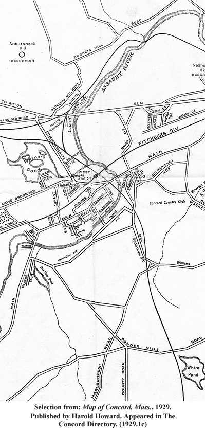
1929.1c Map of Concord, Mass., 1929. Published by Harold Howard. Appeared in The Concord Directory. No scale given. Shows roads, railways, waterways, municipal buildings, and some points of interest. Some portions of the map are missing. 18 x 21.5 in.
Drawer 3:
1929.2 Sketch Plan for Old North Bridge Protective Association, January 11, 1929. Scale 1:960. Shows Mrs. Tanner’s House, outline of Antiquarian Society building, and parking space. 8.5 x 14 in.
Drawer 3:
1936.1 Concord, Mass Survey of Post Office Site, January 10, 1936. Drawn by W. T. Brown. Undated negative photoreproduction. Shows area of Post Office site along Hubbard and Walden Streets and cross-sections of two test pits dug on the site. 2 leaves; 18 x 23.5 in.
Drawer 3:
1936.2 Map of the Town of Concord Massachusetts, October 1936. Scale 1:24,000. 17.5 x 21.375 in.
Drawer 3:
1937.1 Massachusetts State Planning Board Symbols for Land Study Maps, November 1937. Undated photocopy. A WPA project. Shows the various symbols used by the state planning board. 18 x 24 in.
Drawer 3:
1937.2 Plan of Hapgood Wright Forest in Concord, Massachusetts, August 1937. By R. Emerson. Topographical map. Scale 1:1,200. 22 x 26.25 in.
Drawer 3:
1939.1a Land utilization in the Concord area in 1939, 1941. Photocopy, 1991. Appears in Sequent Occupance of a Boston Suburban Community, by Edward Ackerman. Scale 1:42,240. Original located in Special Collections, C.PAM.75 Item D12. 4.125 x 5 in. on an 8.5 x 11 in. sheet.
Drawer 3:
1939.1b Land utilization in the Concord area in 1939, 1941. Undated photocopy. Appears in Sequent Occupance of a Boston Suburban Community, by Edward Ackerman. Scale 1:42,240. Diagrams different uses of land surrounding Concord Center. Original located in Special Collections, C.PAM.75 Item D12. 22 x 27.25 in.
Drawer 3:
1939.2 Land Utilization, Town of Concord, January 1939. Undated photocopy. A WPA project. Scale 1:31,680. Shows how land is being used in Concord. See 1937.1 for map key. 23 x 35 in.
Drawer 3:
1939.3 Soil Classification, Town of Concord, January 1939. Undated photocopy. A WPA project. Scale 1:31,680. 23 x 35 in.
Drawer 3:
1941.1 The Concord area in relation to Greater Boston, 1941. Photocopy, 1991. Appears in Sequent Occupance of a Boston Suburban Community, by Edward Ackerman. Scale 1:779,815. Original located in Special Collections, C.PAM.75 Item D12. 2.375 x 5 in. on an 8.5 x 11 in. sheet.
Drawer 3:
1942.1 Town of Concord in Middlesex County, Massachusetts, 1942. Prepared for the Concord Planning Board. Scales differ. Shows high water line of April 1937. Inset maps of Concord Center and West Concord. 22 x 24 in.
Drawer 3:
1942.2 Town of Concord in Middlesex County, Massachusetts, 1942. Undated reproduction. Prepared for the Concord Planning Board. Scales differ. Shows high water line of April 1937. 13 x 19 in.
Drawer 3:
1942.3 Town of Concord in Middlesex County, Massachusetts, 1942. Prepared for the Concord Planning Board. Scales differ. Some color. Shows high water line of April 1937. 22.5 x 23.5 in.
Drawer 3:
1942.4 Town of Concord in Middlesex County, Mass., 1942. Prepared for the Concord Planning Board from aerial photographs by the Institute of Geographical Exploration, Harvard University. Scale 1:16,000. Shows precinct borders and the high water line of April 1937. 22 x 24 in.
Drawer 3:
1942.5 Town of Concord in Middlesex County, Massachusetts, 1942. Prepared for the Concord Planning Board from aerial photographs by the Institute of Geographical Exploration, Harvard University. Scale 1:19,200. Overwritten with color to indicate high water lines and wooded areas. Wooded areas plotted by A. H. Hepburn. 22 x 24 in.
Drawer 3:
1942.6 Detail of Town of Concord in Middlesex County, Massachusetts, 1942. Prepared for the Concord Planning Board. Shows Revolutionary Ridge and high water line of April 1937. 18.25 x 25.5 in.
Drawer 3:
1942.7 Town of Concord in Middlesex County, Mass., 1942. Prepared for the Concord Planning Board from aerial photographs by the Institute of Geographical Exploration, Harvard University. Key to survey and sections 13 through 20. One piece of tracing paper with notes. 11 x 13.75 in., 11 leaves.
Drawer 3:
1946.1 Town of Concord Mass. Album of Town Maps, 1946. Prepared for the Concord Planning Board from aerial photographs by the Institute of Geographical Exploration, Harvard University. Scale 1:1,920. Includes key to survey. 12 x 15 in., 21 leaves.
Drawer 3:
1946.2 Map of Belknap, Elsinore, and Brooks Streets, 1946. Undated photoreproduction from Town of Concord in Middlesex County, Mass. Cadastral map. No scale given. 10 x 14 in.
Drawer 3:
1946.3 Map of Concord Center, 1946. Undated photoreproduction from Town of Concord in Middlesex County, Mass. Cadastral map. No scale given. 31 x 40 in.
Drawer 3:
1946.4 Map of Nashawtuc Hill, 1946. Undated photoreproduction from Town of Concord in Middlesex County, Mass. Cadastral map. No scale given. 31 x 40 in.
Drawer 3:
1947/50.1 Estabrook Country, June 1947-April 1950. Surveys by Raymond Emerson. Photo reproduced circa 1957. Shows roads and paths through Estabrook Woods. Includes supplemental copy of a letter from Raymond Emerson to Mr. Morgan explaining how to find Two Rod Road. 15.5 x 22 in.; Supplement: 8.5 x 11 in.
Drawer 3:
1948.1 Map of the Town of Concord Massachusetts Showing the Voting Precincts of the Town Effective December 31, 1948, probably circa 1948. Shows three voting precincts in Concord. 8.5 x 11 in.
Drawer 3:
1949 or later.1 Plan of Land: South Bridge Boat House Lot, 1949 or later. Scale 1:720. Shows plan of the South Bridge Boat House lot belonging to George F. and Shirley R. Rohan, located between Main, Elm, and Wood Streets and the Sudbury River. 21 x 24.5 in.
Drawer 3:
1952.1 Map of Punkatasset, June 16, 1952. Undated photocopy. Photomap. Shows Punkatasset Conservation land and surrounding area. Includes supplement describing open space features. No scale given. 3 leaves, 8.5 x 11 in.
Drawer 3:
1952/55.1 Map of Concord and Vicinity Massachusetts, after 1952, before 1955. Published by Interstate Publishing Co., Inc., Everett, MA. Promotional item for the Harvard Trust Company. Some features have been hand colored on map. 19.5 x 26 in.
Drawer 3:
1952/55.2 Map of Concord and Vicinity, after 1952, before 1955. Published by Interstate Publishing Co., Inc., Everett, MA. Promotional item for the Harvard Trust Company. Contains street index. 2 variant copies. 22 x 33 in.
Drawer 3:
1958.1 Concord Mill Dam, October 24, 1958. Undated photoreproduction. From Concord Planning Board Album of Town Maps. Notations added to show number of off-street parking spaces, land use, and condition. 30 x 39.75 in.
Drawer 3:
1958.2 Concord Triangle, October 24, 1958. From Concord Planning Board Surveys. Shows land use, condition, and number of off street parking for buildings along Elm Street, Musketaquid Road, and Nashawtuc Hill. 30.75 x 40 in.
Drawer 3:
1958.3 An Hour’s Traffic Flow in Concord, November 6, 1958. Drawn by C. Lieder. Shows a visual representation of the flow of traffic in Concord by street during the space of an hour. Does not show map layout. 30 x 39.5 in.
Drawer 3:
1959.1 Plan of Land in Concord, Mass., February 1959. Drawn by the Concord Engineering Department. Scale 1:2,400. Shows the Town of Concord Filter Beds in relation to Bedford Street, Sleepy Hollow Cemetery, and Boston and Maine Railroad tracks. 14.75 x 27.25 in.
Drawer 3:
1960.1 Zoning Map of Concord, Massachusetts up to and including Approval by Regular Town Meeting of 1960, 1960. Scale 1:19,200. Shows residence, business, industrial, and bypass zones. 2 copies. 23 x 26.25 in.
Drawer 3:
1960.2 Detail of Nine Acre Corner from Zoning Map of Concord, Massachusetts up to and including Approval by Regular Town Meeting of 1960, 1960. Photoreproduction, 1975. Enlarged by Charles Barker. No scale given. 16 x 20 in.
Drawer 3:
1960.3 Town of Concord Massachusetts Historic Sites, Locations, and Town Street Directory, November 1, 1960. Drawn by A. C. Peters. Scale 1:19,408. Contains street index. 2 copies. 20.875 x 28.75 in.
Drawer 3:
196-.1 Map of Concord, circa 1960s. Published by the New England Map Company. Scale1:24,137. Shows points of interest. Inset photographs of the North Bridge, Emerson House, and the Wayside in Concord and Monroe Tavern and the Hancock-Clarke House in Lexington. Contains street index. 17.5 x 19.5 in.
Drawer 3:
1967.1 Town of Concord Massachusetts, November 1967. Drawn by the Town of Concord Engineering Department. Scale 1:19,200. 21 x 24.375 in.
Drawer 3:
1967.2 Town of Concord Massachusetts, November 1967. Drawn by the Town of Concord Engineering Department with additions by the League of Women Voters of Concord-Carlisle. Scale 1:19,200. In two colors. Shows town owned open spaces, portions of Concord Land Trust property open to Concord residents, federal and state owned properties, schools, and points of interest. Contains street index. 3 copies. 20.75 x 29 in.
Drawer 3:
1968.1 Great Meadows National Wildlife Refuge, September 10, 1968. Scales differ. Shows Refuge owned land and approved acquisition boundaries of Sudbury Division. Concord Division on verso. 10.5 x 16 in.
Drawer 3:
1968.2 Zoning Map of Concord, Massachusetts, 1968. Drawn by the Town of Concord Engineering Department. Scale 1:19,200. Shows various types of residential and commercial zones. 20.25 x 24 in.
Drawer 3:
1970.1 Great Meadows National Wildlife Refuge and Land Status Map, March 12, 1970. By the Fish and Wildlife Service. Shows Refuge-owned land as of September 1971 and approved acquisition boundary. Sudbury Division on recto, Concord Division on verso. Segments of map have titles “Sudbury Division” and “Concord Division.” 10.5 x 16 in.
Drawer 3:
1970.2 Town of Concord Massachusetts, April 1970. Drawn by the Town of Concord Engineering Department. Scale 1:19,200. Contains street index. 21 x 29 in.
Drawer 3:
1971.1 Zoning Map of Concord, Massachusetts, 1971. Drawn by the Town of Concord Engineering Department. Scale 1:19,200. Shows various types of residential and commercial zones. 20.25 x 24 in.
Drawer 3:
1972.1 Great Meadows National Wildlife Refuge, 1972. By the United States Department of the Interior. Undated facsimile. Scales differ. Shows map of the refuge and a map of Pike Trail. Also includes information about the history and use restrictions of the park. 2 sheets, 11 x 17 in.
Drawer 3:
1972.2 Open Land Private & Public, January 1972. Prepared by the League of Women Voters of Concord-Carlisle. Revised from Town of Concord Massachusetts, April 1970 by the Town of Concord Engineering Department. Scale 1:24,000. Some color. Shows town owned land, state or federal land, land trust, private land, flood plains, schools, and points of interest. Contains street index. 3 copies. 18.125 x 25.5 in.
Drawer 3:
1972.3 Site Plan of Sanitary Land Fill, 1972. Surveyed by David W. Perley. Undated photoreproduction. Scale 1:2,400. Some color. Sheet 1 of 9. 25 x 36.5 in.
Drawer 3:
1973.1 Concord Field Station – Estabrook Woods, 1973. By the Museum of Comparative Zoology, Harvard University. Scales differ. Contour interval 10 ft. Shows various types of vegetation within Estabrook Woods. 2 copies. 18.75 x 24 in.
Drawer 3:
1975.1 Generalized Land Use, March 10, 1975. By the Town of Concord. Undated photoreproduction. Scale 1:12,000. Shows zones of different land use. 36 x 46.5 in.
Drawer 3:
1975.2 A Guide to Concord Conservation Lands, March 1975. Undated photoreproduction. Prepared by the Concord Department of Natural Resources. Shows roads and trails through Concord’s conservation lands. Describes land use, regulation, and history. 2 leaves, 11 x 17 in.
Drawer 3:
1975.3 Official Patriots’ Day Map, April 19, 1975. Shows parade route, parking areas, bus routes, medical stations, and blocked roads for bicentennial celebration. 2 copies. 16.5 x 21.5 in.
Drawer 3:
1977.1 Zoning Districts, April 26, 1977. By the Town of Concord. Scale 1:7,200. Shows various types of residential and commercial zones. 2 copies. 20.5 x 26.5 in.
Drawer 3:
1980.1 Historic Districts, Concord, Massachusetts, July 1980. Undated photoreproduction. Prepared for the Historic Districts Commission. Cadastral map. Scale ca. 1:3,692. Map outlines Barrett Farm, Main Street, North Bridge – Monument Square, and American Mile Districts. Also lists Concord sites on the National Register of Historic Places. 24.5 x 42 in.
Drawer 3:
1980.2 Open Land (Public & Private), January 1980. Prepared for the League of Women Voters of Concord-Carlisle. Over written on a November 1, 1977 Town of Concord Planning Map. Scale 1:24,000. Contains street index. Shows wetlands, flood plains, schools, points of interest, town owned land, state and federal land, land trusts, and private land. 16 x 21.5 in.
Drawer 3:
1983.1 The Kalmia Woods, May 1983. Cadastral map. Shows lot numbers, landowners, and renters. Verso contains phone directory of residents. 11 x 14 in.
Drawer 3:
1984.1 Town of Concord, May 1984. Scale 1:24,000. Contains street index. 17.75 x 23.625 in.
Drawer 3:
1984.2 Town of Concord Assessors Tax Maps Index Sheet to 121 Maps, 1984. Undated photoreproduction. Shows Concord with a grid index to the Assessors Tax Maps. 24 x 33 in.
Drawer 3:
1987.1 Concord 1987, 1987. Graphics by Maguire Group Inc. Scale 1:16,000. Colored. Shows locations of town wells, flood plains, permanently protected open spaces, developed areas, and areas deemed critical to Concord’s open space character. Verso contains information about a long range plan meeting. 24 x 30 in.
Drawer 3:
1987.2 Estabrook Woods, June 1987. Drawn by Bill Jameson. Published by the New England Orienteering Club. Topographical map. Scale 1:15,000. Contour interval 2.5 m. Colored. Shows land features within Estabrook Woods. 2 copies. 11 x 15 in.
Drawer 3:
1999.1 Out and About in the SuAsCo Watershed, 1999. Prepared by Applied Geographics, Inc. for the Sudbury Valley Trustees. Scale 1:63,360.Colored. Shows protected open spaces, canoe access points, and Bay Circuit Trail. Verso contains property descriptions and information about canoe access. 24 x 36 in.
Drawer 3:
2000.1 Town of Concord Recreational and Open Space Lands, June 2000. Produced by the Town of Concord Natural Resources Commission. Scales differ. Shows open spaces available for recreation, trails, and access points. Verso contains additional trail maps for seven different public spaces. 2 copies. 20 x 28 in.
Drawer 3:
2002.1 Map of Concord, circa 2002. Published by the Community Phonebook Company. Undated photocopy. 8.5 x 9.5 in. on 2 leaves.
Drawer 3:
sd.1 Map of Punkatasset, undated. Facsimile. No scale given. Shows and describes open space features. 8.5 x 11 in.
Series II. Time-Frame Composite Maps, undated.
Extent: 5 maps.
Scope and Content: Series includes maps that depict changes over time. Includes maps that show land use, land ownership, and town boundary lines. Includes undated reproductions of maps originally produced between 1955 and 1991, and one undated original map.
Known creators represented in this series include Clark, S.; Forman, Richard T. T.; Goldberg, S; Stromeyer, M.; Wood, Albert E.; and Young, A.C. Arranged chronologically by earliest date depicted.
Item List
Drawer 4, Folder 1:
Comp.Ice Age/1635.1 Native Peoples Use of the Land between the Ice Age and 1635, circa 1955. Undated reproduction. By R.T.T. Forman, reproduced from Historic Resources Masterplan of Concord, Massachusetts, 1955. Scale 1:95,040. Shows areas of land occupied by Paleo-Indian/Early Archaic People to Late Woodland People. Map also identifies a Musketaquid community from 1635. 18 x 23 in.
Drawer 4, Folder 1:
Comp.1630/1780.1 Map of Concord in the Colonial Period (Not Including the New Grant), 1967. Undated photocopy. Revised by Henry B. Kane for Ruth R. Wheeler’s Concord: Climate for Freedom, 1967, from a William Wheeler map appearing in Walcott’s Concord in the Colonial Period. Scale 1:56,320. Shows the changing borders and towns surrounding Concord. Includes abandoned highways and modern meeting houses. Hills indicated by hachures. 11 x 15.75 in.
Drawer 4, Folder 1:
Comp.1635/1903.1 Changes 1635 to 1903 Concord and Its Neighbors, circa 1955. Undated reproduction. By R.T.T. Forman, reproduced from Historic Resources Masterplan of Concord, Massachusetts, 1955. No scale given. Shows Concord’s borders in 1635, 1639, 1656, 1712, 1729, 1735, 1754, 1780, 1871, and 1903. 17.75 x 20.75 in.
Drawer 4, Folder 1:
Comp.1635/19--.1 Map of Bedford, Belmont, Concord, Lexington, Lincoln, Newton, Sudbury, Waltham, Watertown, Wayland, and Weston, undated, by A.E. Wood. No scale given. Shows changes in town maps 1635-present, drawn on cloth, with current boundaries drawn in red ink. 12.75 x 18.75 in.
Drawer 4, Folder 1:
Comp.1951/1991.1 Kalmia Woods 1951-1991, September 1991. By S. Clark, M. Stromeyer, and S. Goldberg. Undated photocopy. Cadastral map. Shows homeowners, lists whether or not an occupant or corporate member. 11 x 17 in.
Series III. Cemetery Maps, 1888 – <1977>, undated, (bulk 1949 – 1977)
Extent: 20 maps.
Arrangement: Arranged into three subseries based on cemetery represented: Main Street Burying Ground, New Hill Burying Ground, and Sleepy Hollow Cemetery. Subseries arranged chronologically; in instances of reproduced copies, items are filed by date of original.
Scope and Content: Series includes maps of the cemeteries of Concord, including Sleepy Hollow, Main Street Burying Ground, and New Hill. Maps include surveys of land, lists of plots, and tourist guides to the cemeteries. Materials date from 1888 to 1977, bulk 1949-1977, including many 20th century reproductions of cemetery plot maps.
Known creators represented in this series include Bowditch, Ernest W.; Brown, Merrill A.; Cabot, Chilton; Concord (Mass.). Cemetery Committee; Concord (Mass.). Engineering Dept.; Dee, Charles W.; Smith, Whitney S.; Voight, Charles R.; and Wood, James Barrett.
Item List
Main Street Burying Ground, 1955 – 1960 and undated:
Drawer 4, Folder 2:
Cem.MSBG.1 Map of Main Street Burying Ground, between 1955 and 1960. Undated photoreproduction. By Charles W. Dee, James Barrett Wood, and Charles R. Voight. Shows locations of graves within the cemetery and lists names of people known to be buried at the cemetery that are not noted on the map. 2 copies. 18 x 23.5 in.Drawer 4, Folder 2:
Cem.MSBG.2 Map of Main Street Burying Ground – Index, undated. Shows transcribed list of names by row from the Map of Main Street Burying Ground. 8.5 x 26.5 in.
New Hill Burying Ground, late 1800s – early 1900s:
Drawer 4, Folder 2:
Cem.NHBG.1 Sleepy Hollow Plan of Plots, late 1800s-early 1900s. Shows names of plot owners. 17.75 x 23 in.
Sleepy Hollow, 1888 – 19-- and undated:
Drawer 4, Folder 2:
Cem.SH.1 Section 1. Sleepy Hollow Cemetery Concord, Mass., 1888. By Ernest W. Bowditch. Scale 1:720. Lists plots by number. 20 x 26 in.Drawer 4, Folder 2:
Cem.SH.2 Sleepy Hollow Cemetery Concord, Massachusetts, 1949-1972. Undated photoreproduction. Drawn by Merrill A. Brown, Chilton Cabot, Charles R. Voight, and Whitney S. Smith. Some 1972 revisions on 1949 map. Shows layout of the cemetery with plots named and number. Contains notes from the Cemetery Committee. 13 leaves, 18 x 23.875 in.Drawer 4, Folder 2:
Cem.SH.3 Sleepy Hollow Cemetery Concord, Massachusetts, 1949-1972. Undated photocopy. Drawn by Merrill A. Brown, Chilton Cabot, Charles R. Voight, and Whitney S. Smith. Some 1972 revisions on 1949 map. Shows layout of the cemetery with plots names and numbers. 13 leaves, 18 x 24 in.Drawer 4, Folder 2:
Cem.SH.4a Sleepy Hollow Cemetery, Concord, Massachusetts, April 19, 1961. By the Concord Engineering Department. Scale 1:1,600. Shows the cemetery and locations of notable gravesites. 9.25 x 17.375 in.Drawer 4, Folder 2:
Cem.SH.4b Sleepy Hollow Cemetery, Concord, Massachusetts, April 19, 1961. By the Concord Engineering Department. Shows portion of the cemetery and locations of notable gravesites. 7.875 x 9 in.Drawer 4, Folder 2:
Cem.SH.5a Sleepy Hollow Cemetery, Concord, Mass., 1963. Undated photocopy. By the Town of Concord Engineering Department. Shows detail of Gilmore Avenue section of the cemetery. 24 x 36 in.Drawer 4, Folder 2:
Cem.SH.5b Sleepy Hollow Cemetery, Concord, Mass., 1963. Undated photoreproduction. By the Town of Concord Engineering Department. Shows detail of Gilmore Avenue section of the cemetery, including plot numbers and family names, some added in pencil. 20 x 30.25 in.Drawer 4, Folder 2:
Cem.SH.6a Sleepy Hollow Cemetery, Concord, Mass., 1971. Undated photoreproduction. By the Town of Concord Engineering Department. Shows sections A to F along Ripley Avenue. Shows plot numbers and some family names. 18.25 x 24.25 in.Drawer 4, Folder 2:
Cem.SH.6b Sleepy Hollow Cemetery, Concord, Mass., 1971. Undated photocopy. By the Town of Concord Engineering Department. Shows sections A to F along Ripley Avenue. Shows plot numbers and family names for all plots. 24 x 36 in.Drawer 4, Folder 2:
Cem.SH.7 Sleepy Hollow Cemetery, Concord, Massachusetts, April 19, 1975. Shows the entire cemetery, notable gravesites, and directions to parking at Authors’ Ridge. 9.25 x 17 in.Drawer 4, Folder 2:
Cem.SH.8 Compiled Plan of Land in Concord, Massachusetts Owned by Mary H. Chamberlain, December 21, 1977. Undated facsimile. By Richard B. Alm. Scale 1: 240. Shows 1.12 acre plot of land to become part of the Sleepy Hollow Cemetery. 18 x 24 in.Drawer 4, Folder 2:
Cem.SH.9 Plan of Sleepy Hollow Cemetery, Concord, Massachusetts, undated. Scale 1:1,920. Shows prominent gravesites. 8.25 x 15.5 in.Drawer 4, Folder 2:
Cem.SH.10 Sleepy Hollow Cemetery, Concord, Mass., 19--. Undated photocopy. By the Town of Concord Engineering Department. Shows sections G and H along Chestnut Hollow. 24 x 36 in.Drawer 4, Folder 2:
Cem.SH.11 Map of Chestnut Hollow, Sleepy Hollow Cemetery, 19--. Undated photocopy. Shows numbered plots with some family names. 2 leaves, 11 x 17 in.Drawer 4, Folder 2:
Cem.SH.12a Urn Garden, undated. Shows plots between Sleepy Hollow Avenue and Fountain Avenue. Includes the names of plot owners. 18 x 23.875 in.Drawer 4, Folder 2:
Cem.SH.12b Urn Garden, undated. Shows plots between Sleepy Hollow Avenue and Fountain Avenue. Includes additional plots and family names. 18 x 24 in.
Series IV. Directories and Tourist Maps, 1927 - 1991.
 Extent: 23 maps, 1 document.
Scope and Content: Series includes tourist maps and business directories. Includes maps of Concord published by the Chamber of Commerce and individual businesses for the means of promotion. Maps show many various points of interest related to Concord, Concord’s famous writers, and the Revolutionary War. Includes maps listing local businesses. Also includes self-guided tours of historic locations. Arranged chronologically by date of publication. Known creators represented in this series include Altshuler, Suzanne; Concord Chamber of Commerce (Mass.); Dabrowski, Richard A.; Ferran, Arch; Garfield, Alva Scott; Hatch, Mary Jaquelin; Junior League of Boston; Morgan, R. A.; Owen, F. S.; Stock, Ernest R.; and Wetherill, Kent.
Item List
Drawer 4, Folder 3:
Dir.1927.1 A Map of Historical Concord Showing All the Revolutionary Monuments and Houses of Literary Interest 1775 – 1927, 1927. Undated photocopy. Drawn by Ernest R. Stock. Not drawn to scale. Shows points of interest and ways to reach Concord. 16.75 x 20 in.
Drawer 4, Folder 3:
Dir.1930 or later.1 Concord: Emerson, Thoreau, Alcott, Hawthorne, Sidney, after 1930. Drawn by Kent Wetherill. Not drawn to scale. Hand colored. Inset illustrations of literary houses in Concord. 8.375 x 6.25 in.
Drawer 4, Folder 3:
Dir.1941.1 Advertising map for the Country Store and Wright Tavern, 1941. Drawn by F. S. Owen. Illustrated. Not drawn to scale. Shows main streets and significant locations. 2 copies, one with phone numbers in the margins. 11 x 14 in.
Drawer 4, Folder 3:
Dir.1942.1 A Map of Concord as it is Today, 1942. Drawn by R. A. Morgan. Scale ca. 1:9,051. Shows Concord Center and prominent locations. Hand colored. 2 copies, 1 original, 1 photoreproduction. 15.25 x 19.5 in.
Drawer 4, Folder 3:
Dir.1947.1 Map of Concord compliments of South Bridge Boathouse, 1947. Drawn by Arch Ferran. Illustrated. Hand colored. Shows the locations of 45 places of interest. 12 x 14 in.
Drawer 4, Folder 3:
Dir.1947.2 Map of Concord compliments of South Bridge Boathouse, 1947. Drawn by Arch Ferran. Illustrated. Shows the locations of 43 places of interest. 9.5 x 11.5 in.
Drawer 4, Folder 3:
Dir.1947/65.1 The Concord Guide-Map, after 1947 before 1965. Published by the Concord Press. Shows historic points of interest. Verso contains business listings. 17 x 22 in.
Drawer 4, Folder 3:
Dir.195-.1 A Scott Map of Concord, Massachusetts, circa 1950. Drawn by Alva Scott Garfield. Published by Scott-Maps, Madison, NH. Hand colored. Illustrated map. Shows locations of points of interest, including historic homes, Revolutionary War sites, and Thoreau sites. Includes facts and quotes from Emerson and Thoreau. Two copies, one mounted. 22 x 28 in.
Drawer 4, Folder 3:
Dir.1955/67.1 Map of Concord Massachusetts: A Shoppers Guide, after 1955 before 1967. Published by Community Advertising Co., Brookline, MA. Scales differ. Shows historic points of interest, fire alarm locations, and locations of sponsoring businesses. Map of Lincoln on verso. Contains street index. Some color. 18.5 x 23.75 in.
Drawer 4, Folder 3:
Dir.1963.1 A Treasure Map of People and Places of Concord, Massachusetts, April 1963. Drawn by Mary Jaquelin Hatch. Illustrated. Shows 12 points of interest and includes accompanying illustrations. 2 copies. 18.5 x 24.5 in.; 19 x 25 in.
Drawer 4, Folder 3:
Dir.1975.1a Map & Tours of the Town of Concord, April 1975. Published by The Junior League of Boston, Inc. Scale ca. 1:10,138. Shows visitor services and places of interest. Verso contains information for four self-guided tours. Some color. 17 x 22 in.
Drawer 4, Folder 3:
Dir.1975.1b Map & Tours of the Town of Concord, April 1975. Published by The Junior League of Boston, Inc. Scale ca. 1:10,138. Shows visitor services and places of interest. Verso contains information for four self-guided tours. Concord Free Public Library is circled with the note: “you are here.” Some color. 17 x 22 in.
Drawer 4, Folder 3:
Dir.1975.1c Map & Tours of the Town of Concord, circa 1975. Published by The Concord Chamber of Commerce. Revised edition of Map & Tours of the Town of Concord, April 1975, published by The Junior League of Boston, Inc. Scale ca. 1:10,138. Shows visitor services and places of interest. Verso contains information for four self-guided tours. Some color. 17 x 22 in.
Drawer 4, Folder 3:
Dir.1975.2a Souvenir Map of Concord, Massachusetts: Fifty Historic Sites, 1975. Drawn by Richard A. Dabrowski. Illustrated bird’s eye view of Concord Center. Shows list of famous Concordians and distinguished visitors. Verso contains background information about the fifty sites. 2 copies. 11 x 16.875 in.
Drawer 4, Folder 3:
Dir.1975.2b Souvenir Map of Concord, Massachusetts: Fifty Historic Sites, 1975. Undated facsimile. By Richard A. Dabrowski. Illustrated bird’s eye view of Concord Center. Shows list of famous Concordians and distinguished visitors. Verso contains background information about the fifty sites. Includes supplemental copy of original on verso. 18 x 24; supplement: 11 x 16.875 in.
Drawer 4, Folder 3:
Dir.1975.2c Concord Massachusetts 1635 1775 1975, 1975. Drawn by Richard A. Dabrowski. Illustrated bird’s eye view of Concord Center. Reprint of Souvenir Map of Concord, Massachusetts: Fifty Historic Sites, 1975. Map compliments of Middlesex Institution for Savings. Shows list of famous Concordians and distinguished visitors. Verso contains background information about the fifty sites. 11 x 16.75 in.
Drawer 4, Folder 3:
Dir.1987.1 A Guide to Concord Massachusetts, 1987. Published by the Concord Chamber of Commerce. Drawn by Suzanne Altshuler. Illustrated map. Shows points of interest and locations of sponsoring members of the Concord Chamber of Commerce. Verso lists businesses, churches, municipal buildings, and Chamber of Commerce publications. 18.5 x 24.75 in.
Drawer 4, Folder 3:
Dir.1991.1 A Guide to Concord Massachusetts, 1991. Published by the Concord Chamber of Commerce. Drawn by Suzanne Altshuler. Illustrated map. Shows points of interest and locations of sponsoring members of the Concord Chamber of Commerce. Verso lists businesses, schools, churches, municipal buildings, and Chamber of Commerce publications. 18.5 x 24.75 in.
Series V. Planning Maps, 1946 – 1982.
Extent: 10 maps.
Scope and Content: Series includes maps of proposed changes in Concord, such as land acquisitions, voting precincts, and impacts of school closures. Arranged chronologically by date of original publication. Known creators represented in this series include Concord Journal; Concord (Mass.). Dept. of Public Works; Concord (Mass.). Planning Board; Eddy; and Metcalf.
Item List
Drawer 4, Folder 4:
Plan.1946.1 Town of Concord, Mass. Water Department Water Works System, December 1946. Drawn by Metcalf and Eddy. Shows water mains by size, hydrants, hydrants tested October 1946, high and low services and connections between high and low services. Proposed reinforcements marked in red. 16.5 x 19.25 in.
Drawer 4, Folder 4:
Plan.1947.1 Concord Massachusetts Existing and Proposed Sewerage Systems, 1947. Drawn by Metcalf and Eddy. Scale 1:24,000. Shows existing streets, sewers, and force mains and proposed sewers and force mains. Also shows sewage disposal area. 16.625 x 22 in.
Drawer 4, Folder 4:
Plan.1947.2 Proposed Land Acquisition for Parking Spaces, Road, Pedestrian Way, and Site for Department of Roads & Bridges, March 3, 1947. Reprinted from the Concord Journal. Shows outline of proposed acquisition and roadway that would become Keyes Road. North oriented to the right. 8.5 x 11 in.
Drawer 4, Folder 4:
Plan.1951.1 Areas Under Consideration for Rezoning, March 1951. Shows areas considered for rezoning marked with the corresponding Article Numbers on Warrant. 9.25 x 16 in.
Drawer 4, Folder 4:
Plan.1959.1 Comprehensive Plan Lexington – Lincoln – Concord Battle Road Area, circa 1959. Scale 1: 28,800. Shows historic districts and proposed historic districts around the Battle Road and American Mile area. 8.75 x 21 in.
Drawer 4, Folder 4:
Plan.1967.1 Map of proposed precincts, circa 1967. Shows 6 precinct lines overprinted on Concord Planning Board map. Precincts adopted 1967. No scale given. 10 x 11.25 in.
Drawer 4, Folder 4:
Plan.1973.1 Proposed 1973 Conservation Land Acquisitions, between 1971 and 1973. Revised from Town of Concord, Massachusetts Department of Public Works Land Use Map, May 1971. Scale 1:12,000. Hand colored. 32.75 x 38.5 in.
Drawer 4, Folder 4:
Plan.1981/82.1 Impact of Closing Schools on Bus Routes, 1981-1982. Scale 1:24,000. Overwritten on a Concord Town Planning Board map. Shows what schools students would be bused to if Ripley, Thoreau, or Willard Schools were closed. Hand colored. Related materials in C.PAM.50. 3 maps on 6 11 x 17 in. leaves.
Series VI. Railroad Maps, 1905 – 1967, undated.
Extent: 7 maps.
Scope and Content: Series includes maps of railroad tracks and land owned by Boston and Maine Railroad, Fitchburg Railroad Company, Middlesex Central Railroad, and New York, New Haven, and Hartford Railroad. Items arranged by date with undated materials filed at the end. Known creators represented in this series include Bissell, H.; Hayes, H. W.; and Nelson, A.
Item List
Drawer 5, Folder 1:
RR.1905.1 Railroad Property at Lake Walden, 1905. Undated photoreproduction. By H. Bissell and H. W. Hayes. Cadastral map. Scale 1:1,200. Shows land to be leased by Boston & Maine Railroad to Charles Francis Adams. Lines enhanced with colored ink and tape. 20.25 x 26.25 in.
Drawer 5, Folder 1:
RR.1914/35.1 Right-of-Way and Track Map, Fitchburg R. R. Co., 1914-1935. Undated photoreproduction. North oriented to the lower right. Index of land grants. 25.25 x 56 in.
Drawer 5, Folder 1:
RR.1926.1 Land in Concord, Mass. Boston and Maine Railroad to Commonwealth of Massachusetts, September 1926. Undated photoreproduction. Scale 1:1,200. Shows Boston and Maine Railroad, Fitchburg Division Main Line track in relation to the area surrounding Walden Pond. 9.5 x 14 in.
Drawer 5, Folder 1:
RR.1949.1 Land in Concord, Mass., Boston and Maine Railroad to Helen R. Wright, May 1949. Undated photoreproduction. North oriented to the upper right. Shows a 34.2 acre plot along railway between Boston and Ayer. 9.5 x 14 in.
Drawer 5, Folder 1:
RR.1967.1 Concord, Maynard, and Hudson St. Ry., 1967. Drawn by A. Nelson. Scale 1: 50,688. Shows Boston and Maine Railways and New York, New Haven, and Hartford Railways through Concord, Acton, Maynard, and Hudson. 11 x 16 in.
Drawer 5, Folder 1:
RR.sd.1 Plan Showing the Land Taken by the Middlesex Central R. R. in the Location through Land of J. Noyes, undated. Scale 1:480. Hand colored. North oriented to the lower right. 15.125 x 22.5 in.
Drawer 5, Folder 1:
RR.sd.2 Plan Showing the Land Taken by the Middlesex Central R. R. in the Location through the Land of Mrs. J. S. Keyes, undated. Scales differ. Hand colored. North oriented to the lower right. 15.25 x 22.75 in.
Series VII. Revolutionary War History Maps, 1775, 1896 – 1997.
Extent: 18 maps.
Arrangement: Arranged into subseries by the events of the 19th of April and the Battle of Bunker Hill, and miscellaneous Revolutionary War maps. Items filed in subseries by date; in instances of reproduced copies, items are filed by date of original.
Scope and Content: Series includes maps depicting events of the Revolutionary war, including the paths of midnight rides, lines of marches, and the locations of battles.
Known creators represented in this series include Bowker, Ed; Chisholm, Ivan A.; Fagan, James O.; Heritage Cartography (Firm); Silverberg, Constance Rice; United States. Government Printing Office ; and Wood, Albert E.
Item List
19th of April, 1896 – 1997:
Drawer 5, Folder 2:
Hist. April19.1896.1 Map of Parts of Acton and Concord Mass showing line of March of Cap Isaac Davis Company from his house to the North Bridge, April 19th 1775, 1896. Drawn by Albert E. Wood. Blueprint. 14.75x 21.25 in.Drawer 5, Folder 2:
Hist.April19.19--.1 Picture Story of the Historical Rides of Paul Revere, William Dawes, Dr. Prescott April 18-19, 1775, 19--. Drawn by Ivan Chisholm. Shows the route of the rides, historic sites, and facts about the event. 14 x 17.25 in.Drawer 5, Folder 2:
Hist. April19.1928.1 Picture Story of the Historical Rides of Paul Revere, Wm Dawes, Dr. Prescott April 18-19, 1775, 1928. Drawn by Ivan A. Chisholm, arranged and edited by James O. Fagan. Shows paths of the rides and the British path of retreat. Includes notes on Boston area bridges. Colored. 1 original, 1 reproduction. Original: 12.375 x 15.75 in.; Facsimile: 11 x 17 in.Drawer 5, Folder 2:
Hist. April19.1929.1 Picture Story of the Historical Rides of Paul Revere, Wm Dawes, Dr. Prescott April 18-19, 1775, 1929. Drawn by Ivan A. Chisholm, arranged and edited by James O. Fagan. Shows paths of the rides, Battle Road Concord to Charlestown, and information about the day. 2 copies. 11 x 17 in.Drawer 5, Folder 2:
Hist. April19.1961.1 Map of the line of march of the Acton Minute Men, April 19, 1775, from the home of Captain Isaac Davis to the Old North Bridge at Concord, 1961. Produced by the Captain Isaac Davis Chapter of the Daughters of the American Revolution. Composite of Albert E. Wood map of the line of march, a photograph of the Concord Minuteman Statue, and an illustration of marching Minutemen. 17.5 x 22.5 in.Drawer 5, Folder 2:
Hist. April19.1962.1 Replica of the line of march of the Acton Minute Men, April 19, 1775, from the home of Captain Isaac Davis to the Old North Bridge at Concord, April 1962. Produced by the Captain Isaac Davis Chapter of the Daughters of the American Revolution. Composite of Albert E. Wood map of the line of march, an illustration of marching Minute Men, and photographs of the Concord Minuteman Statue and the Old North Bridge. 17.5 x 22.5 in.Drawer 5, Folder 2:
Hist. April19.1963.1 The Rides of Dr. Samuel Prescott and John Robbins April 18th and 19th 1775 Commemorating the first reenactment in 1962, 1963. Drawn by Constance Rice Silverberg. Rides marked with a red line. Some color. 16 x 20 in.Drawer 5, Folder 2:
Hist. April19.1964.1 The March of the Men of Carlisle to the North Bridge April 19, 1775 Commemorating the first reenactment in 1962, 1964. Drawn by Constance Rice Silverberg. Shows the line of march, town boundaries in 1775, and boundaries of Carlisle in 1780. Some color. 16 x 20 in.Drawer 5, Folder 2:
Hist. April19.1970.1 Picture Story of the Historical Rides of Paul Revere, Wm Dawes, Dr. Prescott, 1970. From maps by Ivan Chisholm. 2 copies. 8.5 x 11 in.Drawer 5, Folder 2:
Hist. April19.1973.1 Battles of Lexington-Concord, 1973. Published by Heritage Cartographers as part of the American Revolutionary War Series. Illustrated map. Shows a chronology of the events of April 19, 1775. Shows illustrations of the Battles of Lexington and Concord, includes map of the routes taken by the British, Revere, Dawes, and Prescott. 23.25 x 31 in.Drawer 5, Folder 2:
Hist. April19.1975.1 The Battle Road Adventure, 1975. Drawn by Ed Bowker. Published by Trav-a-Tapes. Shows the Trav-a-Tapes guided tour route and illustrations of the events of April 19, 1775. Originally accompanied a cassette tape tour. 12 x 35.5 in.Drawer 5, Folder 2:
Hist. April19.1997.1 Map of the Minute Man National Historical Park, 1997. Published by the Government Printing Office. Shows Battle Road, Battle Road Trail, Routes of British Expedition and the Patriot Messengers, and the British retreat from Concord. Includes information on historic sites and the events of April 19, 1775. 15.5 x 16.5 in.
Battle of Bunker Hill, 1775 and undated:
Drawer 5, Folder 2:
Hist.BH.1775.1 The Seat of War in New England, 1775. Shows line of marches to the Battle of Bunker Hill through Massachusetts, New Hampshire, Connecticut, and Rhode Island. Insets of plans of Boston Harbor and a map of Boston showing the attack on Bunker Hill. Colored. Scales differ. 21 x 24.75 in.Drawer 5, Folder 2:
Hist.BH.1775.2 Detail of the Seat of War in New England, 1775. Undated photoreproductions. Shows line of marches to the Battle of Bunker Hill through Massachusetts, New Hampshire, Connecticut, and Rhode Island. 2 copies. Positive: 15 x 18 in.; Negative: 13.215 x 16 in.
Miscellaneous Revolutionary War Maps, undated:
Drawer 5, Folder 2:
Hist.RW.1775 A Plan of the Town and Harbour of Boston, July 29, 1775. Drawn by I. Decosta. Undated facsimile. Shows locations of engagement between British troops and Minute Men and places of encampment in and around Boston. Original located at Brown University, Providence, Rhode Island. 11.5 x 13.25 in.
VIII. Sanborn Fire Insurance Maps, 1897 and 1909.
Extent: 2 books.
Scope and Content: Series includes insurance maps of Concord published by the Sanborn Map Company and its predecessor the Sanborn-Perris Map Co. Materials date from 1897 and 1909. Arranged by date. Creators represented in this series include the Sanborn Map Company and the Sanborn-Perris Map Co.
Related Archival Materials: Additional Sanborn Insurance maps available on microfilm for a range of dates.
Item List
Drawer 5, bottom of drawer:
Sanborn.1897.1 Sanborn Map of Concord, Mass for the Exclusive Use of Brown, Eaton, & Co. Agents, 1897. Published by Sanborn-Perris Map Co., Limited, New York. Cadastral map. Scale 1:600. Colored. Shows roads, buildings, and water pipes. Partial copy, 6 leaves missing. 13.75 x 21.125 in.; 6 leaves (3 sheets)
Drawer 5, bottom of drawer:
Sanborn.1909.1 Concord, Mass., 1909. Published by the Sanborn Map Company, New York. Cadastral map. Scale 1:600. Colored. Shows buildings, roads, and water pipes. Contains index. 13.625 x 21 7.063 in.; 22 leaves (11 sheets)
Series IX. U.S.G.S. Maps, 1911 – 1979, undated.
Extent: 26 maps, 3 documents.
Scope and Content: Series includes maps produced by the United States Geological Survey, or about USGS Triangulation Stations. Includes topographical maps of the Maynard and Concord Quadrangles. Also includes maps relating to surface geology and water resources of the Concord area, including flood maps. Items date from 1911 to 1979, including one undated item. Arranged by year.
Known creators represented in this series include Caswell, William W.; Farrell, D. F.; Gadoury, Russell A.; Geological Survey (U.S.); Koteff, Carl; Petersen, Richard G. (Richard Gray), 1928-; Pollack, S. J.; and Wood, G. K. (George K.).
Item List
Drawer 5, Folder 3:
USGS.1911.1 Reconnaissance Map, Massachusetts, Framingham Sheet, July 1911. Reprint of March 1894 map. By the United States Geological Survey. Topographical map. (W71°30’ – 71°15’ / N42°30’ – 42°15’) Scale 1:62,500. Contour interval 20 feet. Colored. 16.5 x 20 in.
Drawer 5, Folder 3:
USGS.1911.2 Reconnaissance Map, Massachusetts, Framingham Sheet, July 1911. Reprint of March 1894 map. By the United States Geological Survey. Topographic map. (N42°15’ – 42°30’ | W71°15’ – 71°30’) Scale 1:62,500. Contour interval 20 feet. Colored. Mounted on fabric with handwritten notations. 13.25 x 17.5 in.
Drawer 5, Folder 3:
USGS.1943.1 Concord Quadrangle 7 ½ - Minute Series, 1943. By the United States Geological Survey. N4222.5 – W7115/7.5. Scale 1:31,680. Contour interval 10 ft. Colored. Includes Bedford, Lincoln, and Weston. Key to symbols on verso. 17 x 21 in.
Drawer 5, Folder 3:
USGS.1943.2 Maynard Quadrangle 7 ½ - Minute Series, 1943. By the United States Department of the Interior Geological Survey. Topographic map. N4222.5 – W7122.5/7.5. Scale1:31,680. Contour interval 10 ft. Colored. Shows Boxborough, Acton, Concord, Sudbury, Maynard, Stow, Hudson, and Marlborough. Key to symbols on verso. 15 x 20 in.
Drawer 5, Folder 3:
USGS.1943/47.1 Concord Quadrangle 7 ½ - Minute Series, 1947. Reprinted from 1943 edition with corrections. By the United States Geological Survey. Topographic map. N4222.5 – W7115/7.5. Scale 1:31,680. Contour interval 10 ft. Colored. Includes Bedford, Lincoln, and Weston. Key to symbols on verso. 17 x 21 in.
Drawer 5, Folder 3:
USGS.1950.1 Concord Quadrangle 7.5 Minute Series, 1950. By the United States Geological Survey. Topographic map. N4222.5 – W7115/7.5 Scale 1:24,000. Contour interval 10 ft. Colored. Includes Bedford, Lincoln, and Weston. 22 x 27 in.
Drawer 5, Folder 3:
USGS.1950.2 Maynard Quadrangle 7 ½ - Minute Series, 1950. Drawn and published by the United States Geological Survey. Topographic map. N4222.5 – W7122.5/7.5. Scale 1:24,000. Contour interval 10 ft. Colored. Shows Maynard, large portions of Acton, Concord, and Sudbury. 2 copies. 22 x 27 in.
Drawer 5, Folder 3:
USGS.1958.1 Concord Quadrangle 7.5 Minute Series, 1958. By the United States Geological Survey. Topographic map. N4222.5 – W7115/7.5 Scale 1:24,000. Contour interval 10 ft. Colored. Includes Bedford, Lincoln, and Weston. 3 copies, 2 different colorations. 22 x 27 in.
Drawer 5, Folder 3:
USGS.1958.2 Concord Quadrangle 7.5 Minute Series, 1958. By the United States Geological Survey. N4222.5 – W7115/7.5 Scale 1:24,000. Includes Bedford, Lincoln, and Weston. Some color. Missing contour lines. 22 x 27 in.
Drawer 5, Folder 3:
USGS.1964.1 Surficial Geology of the Concord Quadrangle, Massachusetts, 1964. Drawn by Carl Koteff, United States Geological Survey. Scale 1:24,000. Contour interval 10 ft. Includes supplemental writings. 3 copies. Map: 25.875 x 28 in.; Supplement: 2 pages, 8.5 x 11 in.
Drawer 5, Folder 3:
USGS.1965.1 Maynard Quadrangle 7.5 Minute Series, 1965. By the United States Geological Survey. Topographic map. N4222.5 – W7122.5/7.5. Scale 1:24,000. Contour interval 10 ft. Includes portions of Concord, Acton, Stow, and Sudbury. 4 copies with 3 different colorations. 22 x 27 in.
Drawer 5, Folder 3:
USGS.1965/79.1 Maynard Quadrangle 7.5 Minute Series, 1979. By the United States Geological Survey. Topographic map. Revised from 1965 map. N4222.5 – W7122.5/7.5. Scale 1:25,000. Contour interval 10 ft. Includes portions of Concord, Acton, Stow, and Sudbury. 22 x 27 in.
Drawer 5, Folder 3:
USGS.1968.1 Flood of March 1968 on the Sudbury, Assabet, and Concord Rivers, Massachusetts, 1970. By R. G. Petersen, G. K. Wood, and R. A. Gadoury. Photomap. Some color. Shows flood waters and data on high water levels. 2 sheets, 40.5 x 47 in.
Drawer 5, Folder 3:
USGS.1969.1 Water Resources of the Assabet River Basin, Central Massachusetts, 1969. By S. J. Pollack, D. F. Farrell, and W. W. Caswell. Some color. Shows map of Assabet River Basin showing ground water locations and charts outlining precipitation, stream flow, and water levels. 37.5 x 38 in.
Drawer 5, Folder 3:
USGS.1970.1 Concord Quadrangle, Massachusetts – Middlesex Co 7.5 Minute Series, 1970. By the United States Geological Survey. N4222.5 – W7115/7.5. Scale 1:24,000. Contour interval 10 ft. Colored. Includes Lincoln, Bedford, and Weston. 22 x 27 in.
Drawer 5, Folder 3:
USGS.1970/79.1 Concord Quadrangle, Massachusetts – Middlesex Co 7.5 Minute Series, 1970-1979. By the United States Geological Survey. Contour interval 10 ft. Shows 1979 revisions over 1970 map. N4222.5 – W7115/7.5. Scale 1:25,000. Colored. Includes Lincoln, Bedford, and Weston. 2 copies. 22 x 27 in.
Drawer 5, Folder 3:
USGS.sd.1 Map of Triangulation Stations, undated. Blueprint. Shows triangulation stations, traverse stations, and benchmarks located within Concord, separated by the U.S.G.S. and Local Control Survey. 11 x 13.25 in.
c2012 Concord Free Public Library, Concord, Mass.
Not to be reproduced in any form without permission of the Curator of the William Munroe Special Collections, Concord Free Public Library.
Mounted 25th April 2012. rcwh.