ALLEN FRENCH LANTERN SLIDES OF IMAGES PRIMARILY OF MONUMENT SQUARE AND THE MILL DAM IN CONCORD, MASS., [ca. 1920-1930]
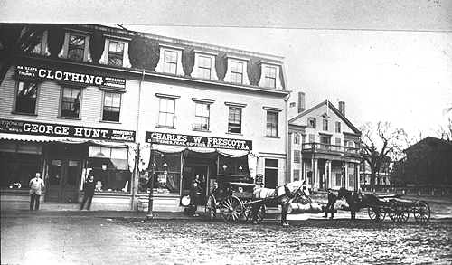
No. 28. Mill Dam, north side, and Monument Square—showing George Hunt
and Charles W. Prescott stores, and the Middlesex Hotel
Vault B5, Unit 9
EXTENT: 105 distinct lantern slides (3 ½” x 4”), plus 8 duplicate slides and 56 negatives, of images of Monument Square and the Mill Dam in Concord , Mass. (photographs, illustrations, and maps), housed in three boxes.
ORGANIZATION/ARRANGEMENT: Organized in a single file; slides listed numerically, as arranged by Allen French.
BIOGRAPHY: Author, historian, antiquarian, and resident of Concord , Mass. ; lecturer on historical and other topics; instructor in English at Harvard and the Massachusetts Institute of Technology. Born in Boston , November 28, 1870 , to John James and Frances Maria Stratton French. Attended Boston schools, M.I.T. (S.B. 1892), the University of Berlin (1892-1893), and Harvard (A.B. 1894). Married Ellen Dorrance and moved to Concord in 1898. The couple had three daughters. Ellen French died in 1918; Aletta Lillibridge became Allen French's second wife in 1922. Allen French was a prolific writer of juvenile stories for serial and book publication and of historical fiction, books based on Icelandic history, works on gardening, and studies of Colonial, Revolutionary, and Concord history. His historical titles include The Siege of Boston (1911), Old Concord (1915), The Day of Concord and Lexington (1925), A British Fusilier in Revolutionary Boston (1926), and The First Year of the American Revolution (1934). His guidebook Historic Concord was first issued as a thin pamphlet in 1924 by the John Hancock Mutual Life Insurance Company, republished in revised and expanded form in 1942, later reissued. (It is still available as revised by David Little and published by the Friends of the Concord Free Public Library.) French traveled to England to read original documents (the Gage papers and other primary materials) relating to the Revolutionary period. Deacon and Sunday school superintendent at the First Parish in Concord, vice president and president of the Concord Antiquarian Society, member (1909-1946) and long-time chairman of the Library Committee of the Concord Free Public Library, member of the Social Circle in Concord from 1919 until his death, founding member and vice president of the Thoreau Society, member of the Saturday Club and Dramatic Club in Concord and, beyond the town, of the Harvard Club, Massachusetts Historical Society, Colonial Society of Massachusetts, New England Historic Genealogical Society, American Antiquarian Society, and Society for the Preservation of New England Antiquities. French died at his Nashawtuc Road home on October 6, 1946.
SCOPE AND CONTENT: A collection of glass lantern slides primarily of the Mill Dam/Monument Square area of Concord , Mass. , prepared by Allen French for lecture purposes between about 1920 and 1930. Also includes images of other historic Concord sites and landscapes (Orchard House, Antiquarian House, North Bridge , Concord River , etc.). The slide images come from photographs, drawings, and maps. The original images from which slides were prepared date from between 1775 and about 1925. Some images are from illustrations by Lester Hornby for Allen French's Old Concord (1915), some from illustrations in J.W. Barber's Historical Collections (1840). Some were created using Allen French's own hand-drawn maps and sketches.
SOURCE OF ACQUISITION : Probably the gift of Allen French.
ACESS/USE: Because these images are fragile, access to them is at staff discretion. All uses of them are subject to the Concord Free Public Library's reproduction and use policies.
PROCESSED BY: Gretchen O'Connor; finding aid completed 07/06.
CONTAINER LIST
Box 1 (plus negatives and duplicate slides as indicated):
1. No slide.
2. Anderson 's Market: Lester Hornby illustration (plus negative).
3. Concord , 1635: drawing by A. French.
4. Mill Dam, south side — Richardson 's Drugstore, draped with flags: photograph (plus 2 negatives and 1 duplicate slide).
5. Location of Concord rivers, brook, hill, and ponds: drawing by A. French.
6. “The Road into Concord, 1636”: drawing by A. French.
7. “The various sites and their influence”: drawing by A. French.
8. Hill, bog, and brook: drawing by A. French.
9. Mill Dam, 1914, looking toward Monument Square: photograph (plus negative).
10. Colonial Inn: photograph (plus negative).
11. “ Concord Begins to Grow — The church, the new roads, the dam & mill, Bulkeley's House”: drawing by A. French.
12. “ Concord — 1650,” showing modern roads and Bulkeley land: drawing by A. French (plus duplicate slide).
12a. Map showing Wheeler Bequest (1687), town land, Mill Brook and pond, Wright Tavern (1747), road to Groton: drawing by A. French.
13. Concord at the time of the Concord Fight (1775): printed map (plus negative and 2 duplicate slides).
14. Amos Doolittle, “Plate II. A View of the Town of Concord ” (1775): engraved illustration (plus negative and duplicate slide).
15. Monument Square , 1775, “Suggested by the Doolittle print: Did the Town House stand free in the Square?”: drawing by A. French.
16. Concord Center , 1830, “From the Hales & Shattuck Map,” including names of businesses and residents: drawing by A. French.
17. Mill Dam, 1810-1820, by Edward Jarvis: hand-drawn map (plus negative and duplicate slide).
18. “Dr. Jarvis' Plan of Concord, 1810-1820”: drawing by A. French.
19. “The Wright Tavern, 1839,” from enlargement of J.W. Barber engraving: tracing by A. French.
20. Concord Center, 1839 — J.W. Barber engraving, looking out from Colonial Inn site, with Court House and Hill Burying Ground on left side, Middlesex Hotel and First Parish Church on right: engraved illustration.
21. Mill Dam, 1810-1820: detail from Edward Jarvis map.
22. Concord, 1852 (from Walling map): drawing by A. French.
23. Mill Dam, ca. 1865, south side, labeled “The Milldam about 1865, as calculated by Mrs. Prescott Keyes from the apparent ages of Mrs. Keyes and Mrs. Richardson who show in this picture”: photograph (plus negative).
24. “The Milldam, Concord , about 1875,” showing south side, snow on the ground: photograph (plus negative).
25. Hill, bog and brook: drawing by A. French. (Similar to No. 8, which differs in having street overlay.)
26. Mill Dam in snow, perhaps around 1865, looking west, showing both sides of the street: photograph (plus negative).
27. Mill Dam, north side, looking toward Monument Square: photograph (plus negative and duplicate slide).
28. Mill Dam, north side, and Monument Square — showing George Hunt and Charles W. Prescott stores, Middlesex Hotel, unpaved road: photograph.
29. “ Concord , 1875,” with 1775 buildings shaded: drawing by A. French.
30. Fountain and trough, Monument Square, and east end of Mill Dam: photograph (plus negative).
31. “Middlesex Hotel, about 1875” (i.e. 1860s?): photograph with guests in windows and on balcony, horses and wagons.
32. “Columbus Celebration by Public schools. Rev. Mr. Reynolds speaking to children. 1890-2?” (dusting of snow on ground): photograph.
33. Soldiers' Monument, Monument Square, with snow: photograph.
34. “Town Property 1867” (with AF notation beside Middlesex Hotel “Unlucky from the start”): drawing by A. French.
35. Colonial Inn building: sketch.
36. Colonial Inn building: photograph (plus negative).
37. Town House, schoolchildren, and Bronson Alcott, early 1860s: photograph (plus negative).
38. “The Old Colonial Inn — Deacon White's Corner”: Lester Hornby illustration (plus negative).
39. “Bake-house and Dwelling,” 1776-1882: drawing by A. French. (Glass slide broken; half missing).
40. “Changes in the L of the Wright Tavern,” 1820-1917: drawing by A. French.
Box 2 (plus negatives as indicated):
41. “The Wright Tavern Decorated for the centennial, 1875”: photograph.
42. “Wright Tavern before 1882 — the ell at full length. Stereograp[h] of Mrs. P. Keyes,” including fountain and flag pole in foreground: photograph (plus negative).
43. “Wright Tavern Corner in 1875,” from maps of 1887 and older stereographs”: drawing by A. French (plus duplicate slide with glass missing).
44. “Changes at Wright's Tavern,” 1755-1882: drawing by A. French.
45. “Plantings in the Square and changes in the entrance to the Milldam,” 1852-1903: drawing by A. French.
46. Concord Center, “From Albert Wood's Map, 1893”: drawing by A. French.
47. Colonial Inn, with automobiles: postcard image (plus negative).
48: Concord Center section of Beers map, 1875, labeled “After … 1872. Before Union Block 1880. Line of street at Tavern is … incorrect”: printed map (plus negative).
49. View across Monument Square to head of Mill Dam, showing horses and carriages, centennial celebration, 1875: photograph (plus negative).
50. “The Old Tree at the Town Hall”: Lester Hornby illustration (plus negative).
51. Concord Center section of [Walling] map, 1856: printed map (plus negative).
52. Soldiers' Monument and Monument Square: photograph (plus negative).
53: Soldiers' Monument (close-up): photograph.
54. “The Square. 1880-1895, when fence taken down”: photograph [by Alfred Munroe].
55. Soldiers' Monument, Colonial Inn building, snow, labeled “From Stereograph, c. 1875”: photograph (plus negative).
56. Mill Dam, sorth side, looking east, showing Albert Stacy's and Tolman's Book and Job Printing Office: photograph (plus negative).
57. Mill Dam, north side, showing John and Joshua Brown building, Middlesex Hotel: photograph (plus negative).
58. “The Jonas Hastings house, torn down for the bldg of Friend's block, 1892”: photograph (plus negative).
59. Soldiers' Monument, Colonial Inn, dusting of snow, labeled “From stereograph, c. 1875”: photograph (plus negative).
60. “From stereograph, showing decorations of 1875”: photograph (plus negative).
61. “Geo. Warren's Gravel Pit — 1920 showing what can be done with Time and a Shovel”: drawing by A. French.
62. “Showing remainder of the original ridge east of Square, 1820-1840”: drawing by A. French.
63. Wright Tavern from Lexington Road: photograph (plus negative).
64. Acton Minute Men — costumed parade on North Bridge, [1925]: photograph.
65. “The Roll of Honor (‘Glory Board') on Middlesex Grounds [former site of Middlesex Hotel], summer of 1919”: photograph (plus negative).
66. Middlesex Hotel in disrepair, cannon in foreground: photograph (plus negative).
67. “Court House and Town Hall, Concord,” labeled by A. French “From [Walling] county map of 1856”: engraved illustration (plus negative).
68. “Colonel Shattuck's residence, Concord” from Barber's Historical Collections: engraved illustration (plus negative).
69. Mill Dam, north side, labeled “1895. I do not remember the traveling home. Trees were cut down in 1908”: photograph (plus negative).
70. Mill Dam, trolley tracks, wires: Lester Hornby illustration (plus negative).
71. Concord Bank building (north side of Mill Dam): photograph (plus negative).
72. South side of Mill Dam, looking west, labeled “C. 1900, when Urquhart bought … his lot. Also trees & horse drawn vehicles. The bush by the 2 men, who have passed the Mdsx.”: photograph.
73. “The Wright Tavern”: Lester Hornby illustration (plus negative).
74. “Milldam — 1917,” with captions dating buildings shown: drawing by A. French. (Slide in poor condition.)
75. “Concord, 1636,” showing first houses built into hill: drawing by A. French. (Slide in poor condition.)
Box 3 (plus negatives as indicated):
76. Monument Square, looking out from Colonial Inn site, between 1885 and 1895: photograph [by Alfred Winslow Hosmer] (plus negative).
77. First Parish Church and Wright Tavern: photograph (plus negative).
78. Concord River: photograph (plus negative).
79. Antiquarian House (Reuben Brown House, Lexington Road): photograph (plus negative).
80. Orchard House (Lexington Road ): photograph (plus negative).
81. Thoreau birthplace (Virginia Road): photograph [by Alfred Winslow Hosmer] (plus negative).
82. Concord River and 1875 version of North Bridge (with gazebos): photograph (plus negative).
83. Hillside Chapel (Concord School of Philosophy), carriage with Alcotts on road: photograph (plus negative).
84. Doorway, Antiquarian Society (Reuben Brown House), Cummings Elothan Davis in doorway: photograph (plus negative).
85. Spring flood, from Nashawtuc: photograph [by Herbert Wendell Gleason] (plus negative).
86. The Old Chapter House of the D.A.R.: Lester Hornby illustration (plus negative).
87. The Unitarian Church (First Parish): Lester Hornby illustration (plus negative).
88. Rear of Elm Street, across Concord River, showing Elm Street houses: photograph (plus negative).
89. First Parish Church, after 1900 fire and rebuilding: photograph (plus negative).
90. Mill Dam, south side, looking east, [1883?]: photograph (plus negative).
91. North Bridge, 1875 version (close-up): photograph [by Alfred Winslow Hosmer] (plus negative).
92. Nashawtuc Bridge and Hill, two women on bridge: photograph (plus negative).
93. Bigelow Tavern buildings (no longer standing): photograph (plus negative). (See Frederic J. Wood, The Turnpikes of New England, 1919.)
94. “District school house, near Emerson's ho[use]?”: photograph.
95. Lexington Road, snow: photograph.
96. Ball/Tarbell/Benson House (formerly on Ball's Hill Road), snow: photograph.
97. “Scene of Emerson's ‘My Garden'” [by Walden]: photograph.
98. “Old Hunt House, pulled down 1852 [i.e. 1859] … Hosmer house behind. See Thoreau. Succession notation in Growth of Forest Trees” [Humphrey Hunt House, no longer standing]: photograph.
99. “Ebenezer Hubbard's House? 1860” (formerly on Walden Street, Post Office site): photograph.
100. Soldiers' Monument: photograph.
101. “ Main St. & Sudbury Road in 1860” (Brooks House — predecessor on site of Concord Free Public Library — now standing on Hubbard Street): photograph.
102. Monument Square, Decoration Day: photograph.
[103]. Concord 's rivers and hills (features unlabeled): drawing by A. French. (Damaged; plates of glass missing.)
[104]. Streets and buildings of Monument Square and Mill Dam, in red (features unlabeled): A. French drawing.
[105]. Separate slide with labels for streets and buildings of previous slide (no buildings or streets shown — only captions, which fit precisely with features in [104]): A. French lettering.
c2006 Concord Free Public Library, Concord, Mass.
Not to be reproduced in any form without permission of the Curator of Special Collections, Concord Free Public Library.
Back to Special Collections homepage