Concord, Massachusetts, Department of Public Works Photograph Collection, 1916-1976
Vault B5 Unit 23
 EXTENT: 1 container.
ORGANIZATION AND ARRANGEMENT: Organized in five series: Series I. Weather; Series II. Road Crews; Series III. Bridges; Series IV. Reservoirs; Series V. Albums and Grouped Photographs.
HISTORY: The Concord Department of Public Works (DPW) is responsible for road design, facilities, construction, mapping and organization, roadworks, snow removal, and street sweeping within the Town of Concord. Waterworks was the first municipal department established (in the late 1800s), but the DPW was not officially created until May 1956, achieved by combining the boards of water and sewer, and roads and bridges.
SCOPE AND CONTENT: 773 photographs,1916-1976, all taken in Concord, Massachusetts or surrounding area. The collection consists of albums and loose photographs generated by the Department of Public Works depicting road building, bridges, snow removal, accident site determinations and weather events such as a flood in 1936 and The Hurricane of 1938.
NOTES/COMMENTS: The photographs in this collection were taken to show the changes in Concord’s buildings, roads, bridges, and inadvertently they are also useful in determining the changes in construction techniques and machinery used in general DPW duties. The men (the laborers are exclusively male) seen in the photos were rarely the intended subjects though feature regularly, consequently the photographs might be useful for research in several distinct social sciences. The weather event photos are impressive in a sensational way and some are quite attractive; photographer’s shadow stretched out over a scene of ice storm wreckage for instance.
PROCESSED BY: JOLF; finding aid created November 2011.
CONTAINER LIST
Series I: Weather
82 photographs of various formats depicting ice storms, fallen trees, downed power lines or flooding in Concord, MA taken during the years 1916 – 1976 by the Department of Public Works or its affiliate bodies.
Folder 1, Envelope 1: Ice storm, 1921 – 1:
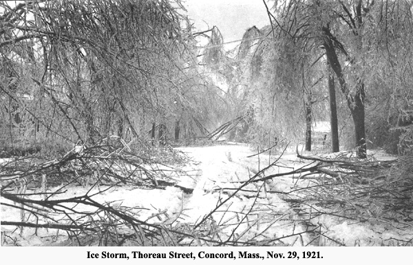
Envelope Description. 27 hand-captioned 2x3 B&W photographs (dated Nov 29, 1921) documenting the aftermath of an ice storm that affected Concord, MA in November of 1921. Includes; fallen trees, downed power lines, ice covered branches, street with tire tracks in snow and a stranded Model A Ford. Each photo has an address handwritten on the reverse. Photographer unknown.
Captions: Monument Sq (2), Squaw Sachum trail, Thoreau St. (2), Lowell Road near Monument Sq., Westerly end of Monument Sq., Lowell Road, Yard of First Parish church, Colonial Hotel, Monument Sq. near Crumb Barn, Walden St near Hubbard (2), Hubbard St, Tree in Nathan Straw yard Walden St, Tree in front Concord High School, Tree in front Colonial, Easterly end of Lowell Rd, Lowell Road at Herbert with Herman, Musketaquid Rd, Monument St in front of Johnson Keyes house, Tree in Nathan Straw yard Walden St, Tree at Chilton Cabot, on Walden St looking to First Parish Church, Thoreau St near home of Ginger Gramer, Thoreau St near Walden easterly end, Trees in front of Johnson Keyes.
Folder 1, Envelope 2: Ice storm, 1921 – 2:
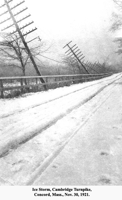
Envelope Description. 34 hand-captioned 2x3 B&W photographs documenting the aftermath of an ice storm that affected Concord, MA in November of 1921. Includes; fallen trees, ice covered limbs, frozen rivers, tire tracks in ice, leaning telephone poles, ice covered power lines, a small snowplow in action. Most photographs have a handwritten description of the address where taken, usually on the front. Most have a purple date stamp (Nov 29, 1921, or Nov 30, 1921) possibly done contemporarily. Photographer unknown. Some duplicates.
Captions: Lowell Rd H.W. Hosmer (3), Hubbard St at Devons, Thoreau St (4), Cambridge Turnpike, Main St east from Thoreau, Monument St at Labots, Sudbury Rd S Lufkin, Fitchburg RR grounds, Looking west at Concord St.
Folder 1, Envelope3: Flood 1936 – 1:
Envelope Description. 18 3”x5” B&W photographs depicting flooding of roads and bridges around Concord, MA. 3/13/36 – 3/17/36. Some cars and pedestrians visible. 4 4”x6” negatives. 1 of Virginia Rd culvert looking upstream. Undated. Circa 1920.
Captions: Pine St March 13 1936 9AM Water reached to arrow 3/13/96 night; Powder Mill Corner March 13 1936, Lowell Rd mar 15 1936 AM, Lowell Rd. Mar. 14 1936 about 4pm Water just trickling over, Lowell Rd looking North March 14 1936, Pine St. 3/15/36, Nashawtuc Rd west from Bridge 3/15/36, Sudbury Rd south from Turnpike 3/15/36, Lowell Rd at Liberty St 3/15/36 [street lamp and detour sign visible], Red Bridge 3/15/36, Nashawtuc Rd 3/15/36, Spencer Brook out of Algiers Pond 3/15/36, Sudbury Rd South from Bigelows Drive 3/15/36 [Road Underwater sign, Road Unsafe sign, road flare visible], Pine St 3/17/36, South Bridge Concord 3/17/36.
Folder 1, Envelope 4: 1936 flood – 2:
Envelope Description. 2 3”x5” B&W photographs of flooded trees.
Caption: Jun 8 1936 [2].
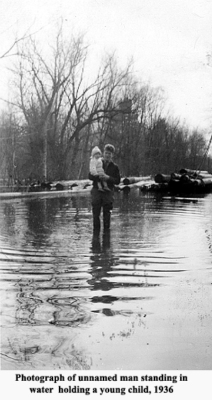
Folder 1, Envelope 5: 1936 man:
Description. 1 2”x4” B&W photograph of unnamed man standing in water holding a young child, 1936.
Caption: Feb 23 1936.
Series II: Road Crews
78 photographs of various formats depicting road crews working in all season with tractors, trucks and snow removal equipment. taken during the years 1930 – 1970 by the Department of Public Works or its affiliate bodies.
Folder 2, Envelope 1: Sweeping leaves ca 1950:
Envelope Description. 9 B&W photographs, various sizes, documenting Town of Concord public works crews clearing leaves from streets. Features men in caps and work clothes including Tony Pagano, a dump truck, tractor with elevator attachment and man pushing motorized basket to gather leaves. No date stamps, ca 1950.
Captions: Tony Pagano.
Folder 2, Envelope 2: Clearing snow ca. 1939:
Envelope Description. 4 BW photographs, 3”x4.5” of a dump truck and a Halss powered elevator with blade attachment. Photographs taken outside Crown Pointe Spa. No date on the photographs but identical form factor to “Concord Roundabout, 1939” series. 3 BW photographs, 3”x4.5” of the Concord roundabout from different angles. Various automobiles. Developed on June 14, 1939 at Cedric G. Chase Laboratories, Inc as per stamp on verso.
Captions: None
Folder 2, Envelope 3: 1938 Road work:
Envelope Description. 7 B&W photographs of various sizes dated from December 9, 1937 to October 3, 1938 as per Cedric G. Chase Laboratories, Inc. developers stamp. Depicts a crane, black top spreader, men working and various automobiles.
Captions: Adnun Black Top Spreader Main St 8/8/38, Break in Middlesex Sportsmans Club Dam 9/19/1938, Sudbury Rd Nov 8 1938 from Sta25+ northerly.
Folder 2, Envelope 4: 1960-1970 Snowblower:
Envelope Description. 1 3”x2.75” B&W Polaroid of a snowblower working towards camera. Beauty salon, drug store and ice cream shop sign visible on left on Commonwealth Ave taken ca 1970
Captions: Feb 1961 Com’ealth Ave.
Folder 2, Envelope 5: Cambridge Turnpike, 1948:
Envelope Description. 16 3.25”x6” B&W photographs of roads and construction of the Cambridge Turnpike, some dated 1948, the rest probably of the period. Photos of 2 boys playing by drilling rig.
Captions: Camb Tpke looking west from Sta 21+00 1948, Lowell Road looking south from Carlisle, Cmb Tpke culvert 1948 showing roof, Lowell Rd looking North opp Bartkus house, Camb Tpke looking East from Sta 23+50 1948, Camb Tpke looking East from Sta 23+00, Camb Tpke 1948 looking East Camb Tpke looking East Hecpliser, Camb Tpke 1948 looking East root of tree at Heclpisers, Cmb Tpke 1948.
Folder 2, Envelope 6: 1940-1950:
Envelope Description. 16 3”x4” B&W photographs taken throughout 1940 depicting snow on Concord Main St and snow removal as well as a group photo of 4 unnamed men.
Captions: 2/16/1940 Milldam [Anderson’s Market and walker in snow possibly holding a rifle], Sudbury Rd South of Bypass Jan 1940 [2], Concord-Lincoln Bound #10 Nov 1940, Mar 25 1940 looking east on Powder Mill Rd from South of Plainfield, Mar 25 1940 looking south on Plainfield Rd from Powder Mill Rd, Forbes Ice Pond Lowell Rd Dec 31 1940 [3], Fairy Land Dec 31 1940 [Forbes Ice Pond]2/22/1940 Barretts Mill Rd from Traf Circle, 2/21/1940 Heywood and Walden Sts.
Folder 2, Envelope 7: 1950-1960:
Envelope Description. 7 B&W photographs various size of Old Pickard Rd, Barrets Hill Rd culvert, Valley Rd and John Peterson, 1951
Captions: Nashawtuc Rd 1951 14ftlong [John Peterson written on verso], Barretts Hill Rd culvert looking east 3/28/51 [2], Old Pickard Road Jan 19 1951 N of Powder Hill Rd, Old Pickard Rd Jan 19 1951 out N of Pickard Farm looking North.
 Folder 2, Envelope 8: 1970 construction:
Envelope Description. 10 3”x3.25” color photographs of front hoe, cement work and workers. Undated, circa 1970.
Captions: None.
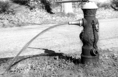
Folder 2, Envelope 9: Water pump, n.d.:
Envelope Description. 7 3”x3.25” B&W photographs of a water pump made of old car engines, and the water leaving the pipeline, n.d.
Captions: None.
128 photographs of Annursnac Hill, Pine Hill, Annursnac and Nashawtuc reservoirs and the Nagog Pumping station all located around Concord, MA. Photos show the construction, finished, and then decaying facilities. Taken 1950-1970.
Folder 3, Envelope 1: Annursnac Hill reservoir construction, 1974, color:
Envelope Description. 48 color photographs, 3.5”x5” showing the newly poured concrete wall surrounding the Annursnac Hill reservoir, detritus on construction site, access roads, crumbling concrete in the basin of the empty reservoir, taken 1974
Captions: All 48 photographs stamped “Engineering Division Oct 21 1974” on verso.
Folder 3, Envelope 2: Annursnac Hill reservoir construction, 1974, B&W:
Envelope Description. 37 B&W photographs, 5”x7” most date stamped August 22, 1974 or Aug 28, 1974. Depicts the construction of the perimeter wall above Annursnac Hill reservoir with the water at various heights. including men in work clothes laying the cement foundation using trucks and wheel barrels. Work crew consists of old and young men. One man noticeable for smoking a cigar while working.
Captions: 7 stamped “Engineering Division Aug 22 1974” on verso. 8 stamped “Engineering Division Aug 28 1974” on verso.
Folder 3, Envelope 3: Annursnac Hill reservoir construction, 1974:
Envelope Description. 2 color Polaroids 3 workers pouring concrete. Cement truck and concrete pumping truck. And, 2 color 5”x7” photographs taken at Annursnac Hill reservoir. 1 depicts a worker smoothing out concrete.
Captions: Annursnac Hill Found. 8/20/1974, Annursnac Hill Foundation 8/20/74 Concrete truck and pump truck (left).
Folder 3, Envelope 4: Pine B&W:
Envelope Description. 11 B&W 8”x10”photographs during constructions of the Pine Hill Reservoir. Photos depict the laying of the concrete slab floor with rod reinforcements. Work men , a crane and cement trucks can be clearly seen.
Captions: All photographs stamped “Concord Police Department” indicating the Police Dept. may have done the developing of these prints. All photos taken by R. Wesinger. Dated from 5/21/69 to 6/16/69. 2 photos dated simply “Sept” and “Aug.”
Folder 3, Envelope 5: Pine Color:
Envelope Description. 4 color 8”x10” and 3 B&W 8”x10” photographs, probably taken during construction of the Pine Hill Reservoir. Photos depict the laying of the concrete slab floor with rod reinforcements. Work men , a crane and cement trucks can be clearly seen. Undated.
Captions: None.
Folder 3, Envelope 6: Pine Interior:
Envelope Description. 2 B&W 8”x10” photographs probably taken inside the completed Pine Hill Reservoir. Shows concrete wall and pillars. Undated.
Captions: All photographs stamped “Concord Police Department” indicating the Police Dept. may have done the developing of these prints. Undated, unsigned.
Folder 3, Envelope 7: Nagog Pumping Station:
Envelope Description. 6 3”x4” B&W photographs of Nagog Pumping Station under construction. November 1955 - January 1956.
Captions: Concord, Mass Nagog Pumping Station Nov 18 1955, Concord, Mass Nagog Pumping Station Dec 4 1955 [2], Concord, Mass Nagog Pumping Station Jan 16, 1955 [2].
Folder 3, Envelope 8: Reservoir 1977:
Envelope Description. 2 5”x7” color photos of unnamed reservoir construction. Several copies. 1 photo features a man and horse.
Captions: Oct 77 [5].
Folder 3, Envelope 9: Reservoir, no date:
Envelope Description. 14 4”6” B&W photos depicting crumbling cement and overgrown grass. Probably Annursnac Hill reservoir, n.d. And, 2 2”x3” B&W photographs of men digging deep in a muddy open reservoir.
Caption: None.
Folder 3, Envelope 10: Nashawtuc, 1974:
Envelope Description. 3 3.25” x 4” B&W photographs of Nashawtuc access stairs, and 4 color 3.25” x 4” Polaroids of Nashawtuc retaining wall, 1974
Captions: Nashawtuc 9-11-74 [7].
Series IV: Bridges
14 photos explicitly taken to document bridges around Concord, MA including the Three Arch Bridge and Westvale Bridge. Taken 1930-970.
Folder 4, Envelope 1: Bridges, 1970:
Envelope Description. 3 B&W 8”x10” photographs of bridges in Dover, Harwich and Great Barrington, MA. Undated, circa 1970.
Captions: Verso of 2 photographs has notes on possible cost to replace bridges. “Dover-Sherborn Est. 45000 remove old bridge 12000 57,000”, Great Barrington Est 25000 remove old bridge 12000 87000”, Harwich Rte 28 – Herring River”.
Folder 4, Envelope 2: Bridges, 1930:
Envelope Description. 2 3”x5” B&W photographs of unnamed road and Three Arch Bridge.
Captions: Road covered by sand spreader July 1931, Three Arch Bridge after widening 1932.
Folder 4, Envelope 3: Four Arch Bridge, n.d.:
Envelope Description. 7 4”6” B&W photographs of a four arched stone bridge, n.d.
Captions: None.
Folder 4, Envelope 4: Westvale:
Envelope Description. 2 4”x5” sepia photographs of Westvale Bridge under construction, n.d. And 1 negative of Westvale Bridge.
Caption: Westvale Bridge.
 Series V: Albums and Grouped Photographs
These photographs are loose or in albums depicting Concord, MA and its streets, houses, road works, weather events and bridges. Taken 1916 -1978.
Item 1: Album 1916-1920:
Envelope Description. Album titled “1916-1919” containing 84 photographs of various sizes showing the construction of roads in and around Concord in various detailed stages, depicting the workmen, horses, and machines used. Also photos of bridges and weather related events. All dated between 1916-1920 many with detailed Caption. Some photos seem to be missing from the album. Photos stapled into album, possibly at a later date.
Captions: THOREAU ST. CONSTRUCTION 9-21-16 AUTO TRUCK DUMPING TOP COURSE STONE STA 54, THOREAU ST. CONSTRUCTION 9-2-16 SEWER TRENCH THROUGH LEDGE INFRONT OF MRS SHANNON’S PLACE, THOREAU ST. CONSTRUCTION 9-2-16 SPREADING TOP COURSE STONE NEAR EVERETT ST, THOREAU ST. CONSTRUCTION 9-2-16 BUILDING LOWER COURSE WITH SAND [2], THOREAU ST. CONSTRUCTION 9-2-16 SPREADING TOP COURSE STONE FROM DUMPING BOARD, THOREAU ST, LOOKING TOWARD BEDFORD JUNE 4 1917, BANK ABVOVE CULVERT IMPRINT OF RIGHT REAR HIND WHEEL, #3 SLOPE OF BANK 75’ E OF CULVERT, LOOKING TOWARD BEDFORD, ALDERS, POLE [utility, damaged] ON FIRTHBURG TURNPIKE OCT 8 1918, Looking NW from Nashawtuc Hill, Cambridge Turnpike bridge April 1919 [4], Bedford St 1917 Top Dees Hill, Bedford ST 1917 Foundation before rolling, Bedford St. const. 1918 before binding Sta. 79 showing stumps, Bedford St 1918, Screen Plant Prescotts Pit 1918, Cambridge Turnpike from Lexington Road 8/30/18, Champion snowplow attachment on GV truck 1918 [2], Fitchurg Turnpike Jct. of Sudbury Rd. 10-8-18, Barrets Mill Rd 1918, Stone crusher Barrets Mill Rd. 1918, Bedford ST 1917, Mudhole on Old Stow Rd. near slaughter House 1916 [2], Bedford St 1918 construction curve near T. Barrys house, Barret Mill Road 10-29-19 [w/ tractor/grader, 2], Camb. Turn. Old Wall 1919, Camb Tpke 1919 Pulling out old abutnebt crib, Camb Tpke bridge 8” centrifugal pump, Camb TPke Bridge July 23 1919 ‘New Cribbing formation’, Cambridge Turnpike 1919, Camb Tpke Lower course near Lincoln Line 1919, Haiss Loader in Carrolls Pit 1919, Main ST. Opp J Sheehan’s looking SE Feb 11 1920, Virginia Rd Culvert 1917 [8], Canoe club Boat house from Minuteman Bridge Mar 19 1920, Lowell Road looking towards Red Bridge [flooded], Lowell Road and Liberty St. Mar 19 1920, Minuteman Bridge Mar 19 1920, Red Bridge Lowell Road looking South East Mar 31 1920, Looking toward town from Red Bridge Lowell Road Mar 19 1920 [2], Geo Albrees Meadow from Cambridge Turnpike from Millbrook bridge Mar 18-1920 looking NE, Arrow indicates Hawthorne’s house Lexington Rd. looking NSE from Millbrook bridge Cambridge Turnpike Mar 18-1920, Arrow indicated downstream abutement Cambridge Tpk. Millbrook Bridge Mar 18-1920 looking NW [2], Cambridge Turnpike Millbrook Bridge Mar 18-1920 looking NW, B&M southern division crossing on Monument St Mar 18-1920, Lowell Rd OPP. CURTISS’S Jan 27 1920, Cor Thoreau and Sudbury Rd looking NE on Sudbury Rd Feb 11 1920, Sudbury Rd and Potter St looking NE John Hagerty’s Mar 18-1920 [2], Main St Opp J. Sheehan’s looking SE Feb 11 1920, Virginia Rd Culvert 1917 [4], Bedford St 1917 [steamroller, 3], Bedford St 1917 Lower course of cobbles, Bedford St bet McGrath & Foss 1917, Mr. Williams, Mr. Lufkin, Mr. Keyes.
Item 2: Album, Ice storm 1920-1921:
Envelope Description. Album titled “1920-1921” containing 34 B&W 4”x6” photographs of showing the construction of roads in and around Concord in various detailed stages, depicting workmen and machines used. Also many photos of November 1921 ice storm. Many with detailed Caption. Some photos seem to be missing from the album. Photos stapled into album, possibly at a later date.
Captions: LOWELL RD OPP MDDLESEX SCHOOL GROUNDS JAN 27 1920, Moving 3 ½ ton block of concrete old crusher foundation Barrett Mill and Strawberry Hill Road Mar 31 1920 [2], 3 ½ ton concrete foundation after rolling from original place Mar 31 1920, Rolling 3 ½ ton concrete foundation out of place, Scraping old crusher location Barrett Mill Rd. Mar 31 1920, Lowell Road infront of Middlesex School Gate Mar 31 1920, Tree Lowell Rd near Jane Hosmer Oct 2 1920 [2], Lowell Road North from Middlesex School Gate Mar 31 1920, Virginia Road culvert looking upstream 8-30-20, Arrow indicates upstream abutment Cambridge Turnpike Millbrook Bridge Mar 18 1920 looking NW, Main St East of J. Sheehan driveway Feb 22 1921 drift about 600’ shoveled out, Lowell Rd Feb 1 1921, Main St. near Powder Mill Pit Jan 1 1921, Lowell Rd HW Hosmer Nov 30 1921, Cambridge Turnpike Nov 28, 1921 [2], Main St east from Thoreau Nov 29 1921, Fitchburg RR Grounds Nov 30 1921, Sandy Pond Road Nov 29 1921, Monument Square Nov 29 1921, Yard of Asa Jacob’s place, Monument St Nov 29 1921, Musketaquid Rd Nov 30 1921, Sudbury Rd S Lufkin Nov 30 1921, Monument St in front of Cabot house Nov 29 1921, Hubbard St at Devons Nov 29 1921, Powder Mill Bridge Mar 28 1921.
Item 3: Album, 1921-1923:
Envelope Description. 37 B&W photographs, mainly 3”x5” depicting bridges, roads, a school and schoolchildren, tractors and snow removal machines. Some photos seem to be missing from the album. Photos stapled into album, possibly at a later date.
Captions: Brighams Corner about 1920 [2], Derby Bridge Mar 28 1921, State Highway Dec 30 1921, Lee’s Bridge Mar 28 1921, Heaths Bridge Mar 28 1921, South Bridge Mar 28 1921, Three Arch Bridge Mar 28 1921, Nashawtuc Bridge Mar 28 1921, Red Bridge Mar 28 1921, The Old North Birdge Mar 28 1921, Flint’s Bridge Mar 28 1921, Pail Factory Bridge Mar 28 1921, Macones Pit Sept 1922, Monument St beyond Pratts 1922 before construction, Monument St at Sawalls 1922, South Side PunRaFasset by McAllister School ulder taken from Monument St 1922, McLaughlin & Martin truck [crashed] 11/1/22, Monument St from 16+50 North 10/28/22, Monument St at Howes 1922 [3], Monument St at Warner Howes showing widening 11/21/22, Roots of big elm taken out in front of Warner Howes Monument St 11/21/21, Monument St in front of Warner Howes 11/21/22 showing widening, Monument St at Sta 79 North Oct 28 1922, 5/14/23 [school and schoolchildren], Feb 3/1923 [snowplow], Elm St corner west from Baker Ave 1/13/23, Sudbury Rd at Potter St Feb 20 1923 Pile {snow] on right is 10 feet high, Lowell Rd Feb 1 1921, Lowell Rd beyond school 3/27/22 Scraper over it once, Lowell Rd beyond school drive 3/27/22 showing effects of scraper, 8 inch pipe taken from Hubbard St in 1922, Tractor towing steam roller Monument St Oct 6 1923 [3], Wood and Elm Streets Jul 19 1923 Reg 331844 [3], Opposite Geo Albrees Oct 30 1923 [3], Geo Albrees [house] 12/8/23 [2], Cletrac pulling truck out of field, State Highway Dept truck stuck in field by Poor Farm.
Item 4: Album 1920-1926:
Envelope Description. 9 4”x6” B&W photographs of winter roads in Concord, MA. Dated January and February 1920. 5 4”x6” B&W photographs of the trucks and Screen Plant at Macones Pit, August 1925. 3 4”x6” B&W photographs of an ice jam at Red Bridge February 14, 1925. 4 4”x6” B&W photographs of snowy roads, featuring a snowplow. From February 1926. 2 4”x6” B&W photographs (copies with different annotatons) describing a car accident March 20, 1926. 7 B&W photographs of various sizes depicting North Bridge repairs, Aug 1926. Men and machinery pictured.
Captions: Lowell Rd Feb 6 1926, Snow Fence on Sudbury Rd Feb 3 1926 Fence 75’ from rd, In form of Oakesplace Feb 7 1926, Just South of Heaths Bridge Feb 7 1926, March 20 1926 Scene od [sic] accident car Reg 495618 arrow points to point where car tipped over about 175 ft west of a slushy spot, there was no ice ridge. Glass.
Item 5: Album 1926-1928:
Envelope Description. 28 3”x5” B&W photographs depicting bridges, roads, flooding, snow, plows, and residential houses. Some photos seem to be missing from the album. Photos stapled into album, possibly at a later date. Cover missing.
Captions: Old Rd to Nine Acre Cor cleaned with 21A plow 12/6/26, 21A plow ob O.R.N.A.C. 12/6/26, 21A plow on O3/4R.N.A.C. 12/6/26, 21A plow on Monument St 12/7/26, Snow fence Sudbury Rd 12/6/26, Cambridge Turnpike March 15 1927 [2], Looking East from Cambridge Turnpike Bridge Feb 28 1927, Looking upstream from Heywood St Feb 28 1927, East from Pine St Nov 5 1927 9AM, Pine St 8/30/27 [4], Pine St Nov 5 1927 9AM [3, flooding visible over road], Monument St March 13 1924 at log cabin [2], Monument St North side of hill Feb 15 1925, Lowell Rd opposite Curtis 2/20/28, Pine St after flood receded Nov 6 1927, Pine St flood Nov 6 1927, Pine St flood Nov 6 1927 after effects [sand bags visible], Hawthorne Lane and Camb Tpke June 7 1928 [4]
Item 6: Album 1929-1932:
Envelope Description. 36 3”x5” B&W photographs of woods, bridges, fields, stone walls, tree roots and road construction in and around Concord, MA taken from 1929-1932. Photos seated in original or early photo corners in the album.
Captions: Old Road to Nine Acre Corner relocation Nov 27 1929 [3], Excavation Old Rd to Nine Acre Cor near Deaconess Farm Dec 1929, Old Rd to 9 Acre Cor from top of hill Dec 1929, Fitchburg Turnpike 1930, Fitchburg Turnpike 1930 before construction, Old Rd to Nine acre Cor Sudbury Rd Sta 56 40’West of E 6/5/31, Fitchburg Tpke from bridge 1930 before removing, Sudbury Rd 5/14/31 Sta 53+50 looking North, Sudbury Rd 5/4/31 Sta 44 looking North, Starlane Sudbury Rd 5/4/31 Sta 72+50 looking South [2], Sudbury Rd 5/4/31 Sta 48 looking North, Sudbury Rd 6/5/31 Sta 65 NW, Sudbury Rd 5/20/31 Sta 83+10 25’ LV of new CL [centerline] looking North, Sudbury Rd Sta 79 North 6/5/31, Sudbury Rd and Old Rd to Nine Acre Corner 6/5/31, Tree felled by wind Monument St opp. J Vindhol Aug 1931 [2], Williams Rd opp M Williams before widening Nov 5 1931, Wheeler Rd Sudbury Rd from Sta 34+ North 6/5/31, haulig stump from Main St sidewalk 10/30/31, Sandspreader July 1931 [2], Sansspreader n 2nd load Barnes Hill Rd 6/18/31, Three Arch Bridge after widening 1931, Barretts Mill Rd looking West at Spencer Brook Aug 1932 [2].
Item 7: Album 1933-1938:
Envelope Description. 46 mainly 3”x5” B&W photographs of road construction, a flood in March 1936 and hurricane damage in September 1938 all taken in and around Concord, MA taken. Many photos seated in original or early photo corners in the album. Some missing.
Captions: Powder Mill Rd South from Old Marlboro Rd 3/33, Hildreths Corner July 13 1933 [2], Hildreths Corner looking West July 13 1933, Hildreths Corner July 13 1933 North, Thoreau and Walden Sts 1936 before construction [2], Flood Mar 1936 Lowell Rd North of Standard Oil Co [couple in canoe floating by house], Walden St 1937 from about Sta 88 northerly, Flood Mar 1936 Lowell Rd looking north towards Red Bridge, Flood mar 1936 Lowell and Liberty St [2], Flood 1936 Sudbury Rd looking towards Heath Bridge [flooded], Flood 1936 Old North Bridge, Flood 1936 Lees Bridge, Flood 1936 Roger Swaim House at Flints Bridge, Mar 13 1936 11AM [2], Flood 1936 Sudbury Rd looking South from Fitchburg Turnpike, Hurricane September 21 1938 Middle Street [trees uprooted] looking Northeast, Hurricane September 21 1938 Middle Street [trees uprooted] Willard Common, Hurricane September 21 1938 Middle Street [trees uprooted] Hubbard St opp Congressional Church, Hurricane September 21 1938 Middle Street [trees uprooted] Sudbury Rd Southeast from Grant Street, Hurricane September 21 1938 Middle Street [trees uprooted] Old Bedford Rd Henry Mahan looking SW, Hurricane September 21 1938 Middle Street [trees uprooted] Battleground, Bay City shovel digging stumps 10/1938 Walden St, Geo Roots pit showing stumps from hurricane 10/14/1938, Hurricane September 21 1938 Middle Street [trees uprooted] Thoreau St looking toward station, Hurricane September 21 1938 Middle Street [trees uprooted] Monument St southerly towards Court Lane, Hurricane September 21 1938 Middle Street [trees uprooted] Monument St looking North from Court Lane, Hurricane September 21 1938 Middle Street [trees uprooted] Bedford St at Oscar John’s, Hurricane September 21 1938 Middle Street [trees uprooted] Tanner House form Battleground, Hurricane September 21 1938 Middle Street [trees uprooted] Main St north side looking east of Nashawtuc Rd, Hurricane September 21 1938 Middle Street [trees uprooted] Monument St Charles Ward’s house, Hurricane September 21 1938 Middle Street [trees uprooted] Lexington Rd TW Surrette’s house.
Item 8: Albums, 1941:
Envelope Description. 2 small photo albums of the Cambridge Turnpike; 13 B&W 3x5 photographs total. Road views, some houses and utility poles visible. No annotations.
Captions: None.
Envelope 1: 1916:
Item Description. 1 4”x6” B&W photo, dated 1916, thus the oldest in the collection. Street view of Lexington Road in Concord, MA featuring several houses and utility poles.
Captions: LEXINGTON RD. LOOKING SOUTH (CONCORD SECTION) OPPOSITE CULL’S PLACE JAN-25-1916.
Envelope 2: Connecticut River 1920:
Envelope Description. 7 B&W 4”x6” photographs of the Connecticut River including skylines of Springfield, MA. Dated 8/11/20 – 8/14/20.
Captions: Conn. River + Springfield City Town Hall tower 8/11/20, Old Bridge over Conn. At Springfield to be replaced with concrete construction 8/11/20, View of Springfield Mass form City Hall Tower 8/12/20, Conn R. + Springfield SW 8/12/20, Conn River 8/12/20, Conn. R. at Sunderland 8/12/20, Conn. River valley at foot of Mt. Holyoke 8/12/20.
Envelope 3: Loose, 1916-1920:
Envelope Description. Miscellaneous photographs of roads around Concord, MA circa 1920.
Captions: Lowell Rd OPP. CURTISS’S Jan 27 1920 [3], Lowell Rd OPP. Jan 27 1920, Dakin’s Hill Lowell Rd Jan 27 1920, Bedford St Const 1918 Sta 86 before surface, Elm St. Concord showing winter patch on hill 1919.
Envelope 4: Trustmar Pond:
Envelope Description. 4 3.25”x4” B&W photographs of a ditch at Trustmar Pond, 1960-1970.
Captions: 11-12-70, 11-11-70 [3].
Envelope 5: D’Amico Sewer Job:
Envelope Description. 9 3.25”x4” B&W photographs of the construction of sewer pipe trench. Workman points out crack in pipe in one photo, 1960-1970.
Captions: May 16, 1963 7pm D’Amico sewer job pipe looking from Station 3+8L to M.H. Station 3+00 (M.H. not completed) Seven lengths laid this date, May 16, 1963 7pm D’Amico sewer job End of pipe Station 3+8L looking toward river 7 lengths laid this date.
Envelope 6: Walnut St. Circle:
Envelope Description. 5 3.25”x4” B&W photographs of Walnut St. Circle with and without snow, 1960-1970.
Captions: Segadelli –Walnut St. Circle Sun. Mar. 13 1966 8:20am complained plows had plugged his driveway. Wanted a front-end loader dispatched immediately to remove snow. 8:45am investigated and found driveway open. Pile of snow no right hand side and took pictures. No action taken.
Envelope 7: Lowell Road, 1949:
Envelope Description. 5 3.25”x6” B&W photographs of road and barrier on Lowell Road, 1949.
Captions: 1949 Lowell Rod North from Westford Rd, Lowell Rd North from H.J. Ryan 1949 [2], Lowell Road looking North from north of Broftkus [2], Cambridge Turnpike looking West.
Envelope 8: Pine St., 1941:
Envelope Description. 4 4”x6.25” B&W photographs of Pine St and bridge. Car, houses and some snow visible. Dated 1941.
Captions: Pine Street March 1941 looking North, Pine St Bridge March 1941 looking West [2], Pine St Bridge looking West from N.V.NH. RR Bridge March 1941.
Envelope 9: 1955:
Envelope Description. 3 4”x6.25” B&W photographs of Mill Dam construction and others 1955.
Captions: South side of Mill Dam Aug 22 1955, Slum Heaths Bridge Aug 23 1955, Corner Liberty St and Lowell Rd Aug 23 1955.
Envelope 10: Nagog 1973:
Envelope Description. 17 4”6” color photographs of standing water, possibly floodwater and structure marked “The Scupper”, 1973
Captions: Nagog East Side DNS 4-4-73 Scraps of rigid insulation, Nagog East Side DNS 4-4-73 [4], Nagog West Side DNS 4-4-73 [2], Nagog East Side DNS at culvert 4-4-73, Nagog West Side DNS at culvert 4-4-73.
Envelope 11: Polaroids 1973:
Envelope Description. 28 3”x4” Polaroid color Land Photographs of various subjects; brackish flooding, some back road work, and damaged cement. Taken between 1972-1973.
Captions: #1 Emerson OMR (rightside), #2 Orchard OMR (left side), #3 MaCarthur OMR (right side), #4 Macarthur OMR (left side), #5 Emerson OMR , #6 Orchard OMR, John R Coleman 73 Dedication of Hugh Cargill Well, Mr and Mrs Arthur Stevenson, Scupper Pond 9-8, Culvert across 2A Nagag woods 9-8, Allen Trustman Prop. 5-11-72 Encroachment on ROW Powder Mill Road, Hosmer prop 12-14-72 Elm Street, Behind Stop + Shop 4-6-73, TNK 5-1-73, Plug in culvert 8/3/73 from Scupper Pond into Nagog, Dam between Scupper Pond and culvert into Nagog 8/3/73, SW Corner 12.12.73 [2], NW Corner 12.12.73.
Envelope 12: Swamp Brook 1973:
Envelope Description. 28 3”x4” Polaroid B&W photographs of Sudbury Road, 1973.
Captions: Headwall Swamp Brook at Sudbury Road upstream 1:45 4-4-73, Headwall Swampbrook at Sudbury Road upstream 1:45 4-4-73 –Ignachuck, Headwall Swampbrook at Sudbury Road downstream 1:45 4-4-73.
Envelope 13: Powder Mill Rd., 1973:
Envelope Description. 4 3”x4” Polaroid B&W photographs of Sudbury Road and Powder Mill Road, 1973.
Captions: School disposal field off Powder Mill Road 2-3-73, 2-3-73 off Sudbury Rd, 2-3-73 Sudbury Rd Dromsek, 2-3-73 Powder Mill Rd.
Envelope 14: Houses, 1974:
Envelope Description. 2 3.25” x 4” color Polaroids of houses in the woods, 1974.
Captions: Judy Bond’s House at Nagog 9-8-74, [the other undated].
Envelope 15: 1975 Miscellaneous:
Envelope Description. 2 3”x3.25” B&W photographs of a plywood dam. 1975
Captions: 1/27/75 [2].
Envelope 16: 1978 Miscellaneous:
Envelope Description. 4”x6” color photograph of plowed snowy street. Car in foreground. Feb 1978.
Caption: Feb 1978.
Envelope 17: 1923 Miscellaneous:
Envelope Description. 2 4”x6” B&W photographs of roads and barricades in Concord, MA
Captions: Reg 331844 Corner Wood and Elm July 19 1923 From Point 320 ft from barricade, Reg 331844 Corner Wood and Elm July 19 1923 [3], Nov 19 1923.
Envelope 18: Man and barrel in boat, n.d.:
Envelope Description. 4 4”x6” B&W photographs of a man, possibly policeman, in a small boat with outboard and barrel at prow, n.d.
Captions: None.
Envelope 19: Miscellaneous:
Envelope Description. 25 miscellaneous photographs of varying sizes and formats depicting empty roads, a flooded bridge, concrete work, an empty reservoir and some unpopulated street scenes. Most undated with no caption. Dates range from ca 1920-1970.
Captions: Frank Falgarrano Reading 944-7490, Concord dump, Ice Pond Road Lowell Dec 31 1940, Old Powder Mill Road April 1928.
c2011 Concord Free Public Library, Concord, Mass.
Not to be reproduced in any form without permission of the Curator of the William Munroe Special Collections, Concord Free Public Library.
Mounted 30 Nov. 2011. rcwh.